Tirat Karmel night lights from space
Night Light of Tirat Karmel (Haifa) from space (Israel) Src. Average luminocity for 10x10km area is 61.9056% and for 50x50km: 35.3288%.
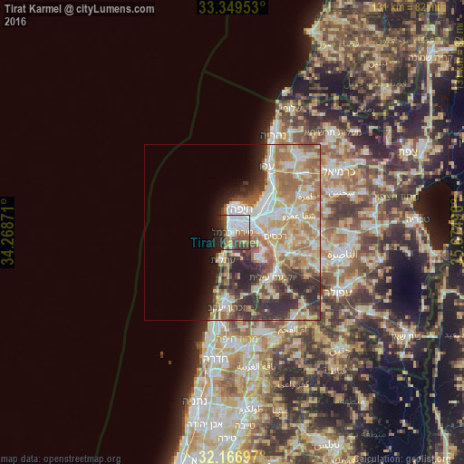
Analysis of Tirat Karmel night lights 2016
Square area 10x10 km:
 27.97%
90-99
6.99%80-89
4.72%70-79
2.27%60-69
5.42%50-59
11.01%40-49
10.49%30-39
8.04%20-29
12.24%10-19
10.84%0-9
0%Square area 50x50 km:
6.73%90-99
6%80-89
7.25%70-79
5.16%60-69
6.56%50-59
4.3%40-49
3.98%30-39
5.26%20-29
7.67%10-19
4.04%0-9
43.03%Clear (daylight) street map image can be seen on geolist.org.
Map coordinates:
33° 20' 58.3" North, 34° 16' 7.4" East
32° 45' 36.8" North, 34° 58' 18.6" East
32° 10' 1.1" North, 35° 40' 29.9" East
Some cities around Tirat Karmel sort by population:
• Haifa
6.7 km =4.2 mi,  13°
13°
• Qiryat Ata
14.4 km =8.9 mi,  66°
66°
• Qiryat Moẕqin
13.1 km =8.1 mi,  49°
49°
• Qiryat Yam
13.5 km =8.4 mi,  42°
42°
• Qiryat Bialik
13 km =8.1 mi, 54°
• Daliyat al Karmel
10.2 km =6.3 mi,  136°
136°
• Nesher
6.8 km =4.2 mi,  84°
84°
• Rekhasim
12 km =7.5 mi,  95°
95°
293308 (p: 18,993)
Sources (retrieved 2019-11-25):
» Earth at Night: Flat Maps 2012, 2016