Qalansuwa night lights from space
Night Light of Qalansuwa (Central District) from space (Israel) Src. Average luminocity for 10x10km area is 91.1795% and for 50x50km: 59.212%.
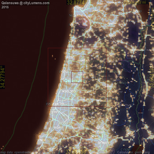
Analysis of Qalansuwa night lights 2016
Square area 10x10 km:
 27.11%
90-99
31.68%80-89
31.5%70-79
5.86%60-69
2.75%50-59
1.1%40-49
0%30-39
0%20-29
0%10-19
0%0-9
0%Square area 50x50 km:
13.3%90-99
13.54%80-89
11.7%70-79
8.69%60-69
6.52%50-59
6.98%40-49
7.56%30-39
7.16%20-29
8.13%10-19
3.56%0-9
12.88%Clear (daylight) street map image can be seen on geolist.org.
Map coordinates:
32° 52' 38.6" North, 34° 16' 40.6" East
32° 17' 5.7" North, 34° 58' 51.8" East
31° 41' 18.8" North, 35° 41' 3.1" East
Some cities around Qalansuwa sort by population:
• Ţūlkarm, PS
5.3 km =3.3 mi,  57°
57°
• Eṭ Ṭaiyiba
3.3 km =2.1 mi,  128°
128°
• Kefar Yona
5.6 km =3.5 mi,  309°
309°
• Tirah
6.4 km =4 mi,  207°
207°
• Even Yehuda
9 km =5.6 mi,  259°
259°
• Tel Mond
7.1 km =4.4 mi,  236°
236°
• Dhannābah, PS
6.5 km =4 mi, 60°
• Pardesiyya
7.1 km =4.4 mi,  288°
288°
293896 (p: 16,898)
Sources (retrieved 2019-11-25):
» Earth at Night: Flat Maps 2012, 2016