Bet She’an night lights from space
Night Light of Bet She’an (Northern District) from space (Israel) Src. Average luminocity for 10x10km area is 49.4304% and for 50x50km: 36.8895%.
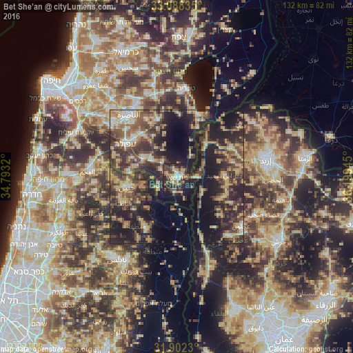
Analysis of Bet She’an night lights 2016
Square area 10x10 km:
 4.4%
4.4%90-99
5.68%80-89
10.81%70-79
7.14%60-69
4.76%50-59
9.71%40-49
13.55%30-39
10.44%20-29
26.56%10-19
6.96%0-9
0%Square area 50x50 km:
2.23%90-99
3.29%80-89
7.25%70-79
6.05%60-69
4.61%50-59
5.45%40-49
9.79%30-39
9.46%20-29
14.59%10-19
21.73%0-9
15.55%Clear (daylight) street map image can be seen on geolist.org.
Map coordinates:
33° 5' 18.1" North, 34° 47' 35.5" East
32° 29' 50.2" North, 35° 29' 46.8" East
31° 54' 8.3" North, 36° 11' 58" East
Some cities around Bet She’an sort by population:
• Janīn, PS
18.8 km =11.7 mi,  257°
257°
• Aţ Ţayyibah, JO
21.4 km =13.3 mi,  76°
76°
• Şammā, JO
19.9 km =12.4 mi,  65°
65°
• Kafr Abīl, JO
18 km =11.2 mi,  119°
119°
• Waqqāş, JO
11.4 km =7.1 mi,  63°
63°
• Dayr Abū Ḑa‘īf, PS
13.4 km =8.3 mi,  250°
250°
• Ḩalāwah, JO
20 km =12.4 mi,  128°
128°
• Tibnah, JO
22.1 km =13.7 mi,  96°
96°
295435 (p: 16,800)
Sources (retrieved 2019-11-25):
» Earth at Night: Flat Maps 2012, 2016