Waqqāş night lights from space
Night Light of Waqqāş (Irbid) from space (Jordan) Src. Average luminocity for 10x10km area is 25.1374% and for 50x50km: 37.8458%.
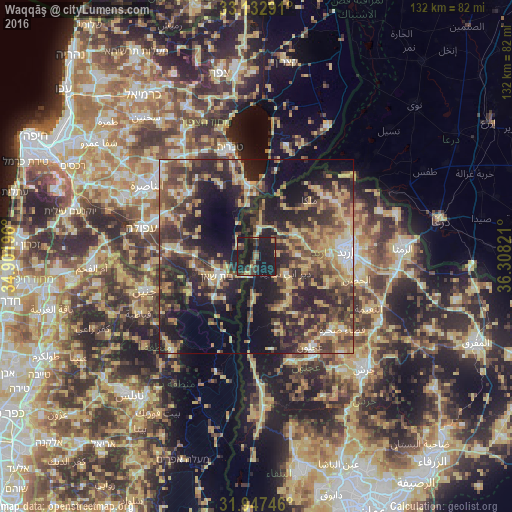
Analysis of Waqqāş night lights 2016
Square area 10x10 km:
 0%
0%90-99
0.37%80-89
3.3%70-79
2.2%60-69
2.56%50-59
2.75%40-49
9.34%30-39
5.86%20-29
6.59%10-19
66.85%0-9
0.18%Square area 50x50 km:
2.12%90-99
2.94%80-89
7.76%70-79
6.65%60-69
5.3%50-59
5.88%40-49
10.05%30-39
9.05%20-29
15.35%10-19
19.57%0-9
15.34%Clear (daylight) street map image can be seen on geolist.org.
Map coordinates:
33° 7' 58.5" North, 34° 54' 7.1" East
32° 32' 31.7" North, 35° 36' 18.3" East
31° 56' 50.9" North, 36° 18' 29.6" East
Some cities around Waqqāş sort by population:
• Bet She’an, IL
11.4 km =7.1 mi,  243°
243°
• Aţ Ţayyibah
10.5 km =6.5 mi,  89°
89°
• Şammā
8.6 km =5.3 mi,  67°
67°
• Kafr Asad
11.8 km =7.3 mi,  58°
58°
• Bayt Yāfā
17.1 km =10.6 mi,  97°
97°
• Kafr Abīl
14.9 km =9.3 mi,  158°
158°
• Tibnah
13.9 km =8.6 mi,  122°
122°
• Qumaym
12.6 km =7.8 mi, 74°
245989 (p: 5,678)
Sources (retrieved 2019-11-25):
» Earth at Night: Flat Maps 2012, 2016