Şammā night lights from space
Night Light of Şammā (Irbid) from space (Jordan) Src. Average luminocity for 10x10km area is 48.722% and for 50x50km: 38.244%.
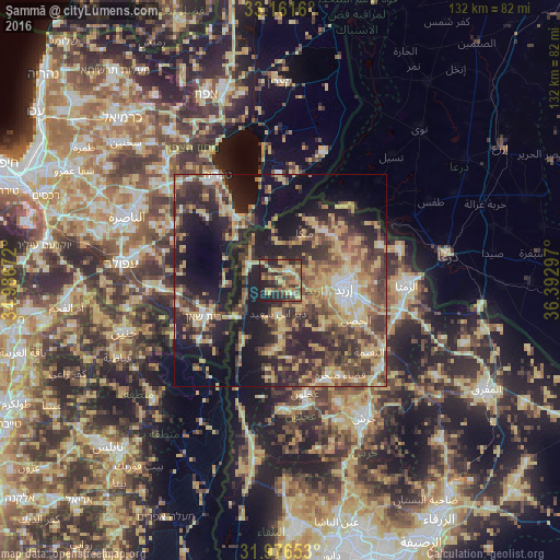
Analysis of Şammā night lights 2016
Square area 10x10 km:
100  0.7%
0.7%
90-99 2.62%
80-89 14.69%
70-79 10.31%
60-69 6.12%
50-59 10.84%
40-49 13.64%
30-39 8.04%
20-29 21.5%
10-19 11.54%
0-9 0%
0.7%90-99
2.62%80-89
14.69%70-79
10.31%60-69
6.12%50-59
10.84%40-49
13.64%30-39
8.04%20-29
21.5%10-19
11.54%0-9
0%Square area 50x50 km:
100 2.19%
90-99 3.2%
80-89 8.64%
70-79 7.13%
60-69 5.19%
50-59 5.93%
40-49 9.7%
30-39 8.13%
20-29 13.62%
10-19 19%
0-9 17.27%
2.19%90-99
3.2%80-89
8.64%70-79
7.13%60-69
5.19%50-59
5.93%40-49
9.7%30-39
8.13%20-29
13.62%10-19
19%0-9
17.27%Clear (daylight) street map image can be seen on geolist.org.
Map coordinates:
33° 9' 41.8" North, 34° 59' 12.2" East
32° 34' 15.7" North, 35° 41' 23.4" East
31° 58' 35.5" North, 36° 23' 34.7" East
Some cities around Şammā sort by population:
• Aţ Ţayyibah
4.1 km =2.5 mi,  140°
140°
• Kafr Asad
3.7 km =2.3 mi,  35°
35°
• Bayt Yāfā
10.5 km =6.5 mi,  120°
120°
• Malkā
12.9 km =8 mi,  25°
25°
• Waqqāş
8.6 km =5.3 mi,  247°
247°
• Ḩātim
11.6 km =7.2 mi,  45°
45°
• Tibnah
11.3 km =7 mi,  160°
160°
• Qumaym
4.2 km =2.6 mi,  88°
88°
247015 (p: 8,926)
Sources (retrieved 2019-11-25):
» Earth at Night: Flat Maps 2012, 2016