Mallow night lights from space
Night Light of Mallow (Munster) from space (Ireland) Src. Average luminocity for 10x10km area is 8.8161% and for 50x50km: 2.5353%.
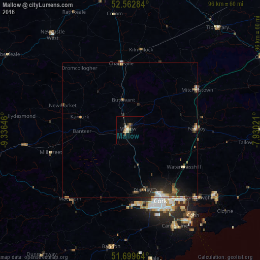
Analysis of Mallow night lights 2016
Square area 10x10 km:
 0.66%
0.66%90-99
1.72%80-89
1.19%70-79
1.19%60-69
1.46%50-59
0.66%40-49
1.72%30-39
1.19%20-29
0.26%10-19
1.46%0-9
88.49%Square area 50x50 km:
0.26%90-99
0.33%80-89
0.21%70-79
0.34%60-69
0.33%50-59
0.2%40-49
0.48%30-39
0.51%20-29
0.94%10-19
1.81%0-9
94.59%Clear (daylight) street map image can be seen on geolist.org.
Map coordinates:
52° 33' 46.2" North, 9° 20' 11.3" West
52° 7' 60" North, 8° 37' 60" West
51° 41' 58.7" North, 7° 55' 48.8" West
Some cities around Mallow sort by population:
• Cork
28.4 km =17.6 mi,  156°
156°
• Luimneach
59.1 km =36.7 mi,  0°
0°
• Carrigaline
39.2 km =24.4 mi, 155°
• Cobh
39.1 km =24.3 mi,  143°
143°
• Midleton
39.3 km =24.4 mi,  128°
128°
• Youghal
57.3 km =35.6 mi,  110°
110°
• Newcastle West
45.6 km =28.3 mi,  320°
320°
• Bandon
43.6 km =27.1 mi,  189°
189°
2962714 (p: 9,495)
Sources (retrieved 2019-11-25):
» Earth at Night: Flat Maps 2012, 2016