Bandon night lights from space
Night Light of Bandon (Munster) from space (Ireland) Src. Average luminocity for 10x10km area is 4.3333% and for 50x50km: 5.4258%.
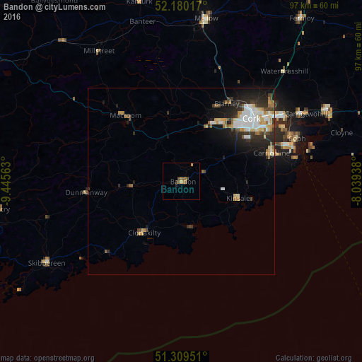
Analysis of Bandon night lights 2016
Square area 10x10 km:
100  0%
0%
90-99 0%
80-89 0.56%
70-79 0.56%
60-69 2.24%
50-59 0.42%
40-49 1.68%
30-39 0.56%
20-29 0.7%
10-19 0%
0-9 93.28%
0%90-99
0%80-89
0.56%70-79
0.56%60-69
2.24%50-59
0.42%40-49
1.68%30-39
0.56%20-29
0.7%10-19
0%0-9
93.28%Square area 50x50 km:
100 1%
90-99 1.06%
80-89 0.62%
70-79 0.69%
60-69 0.62%
50-59 0.47%
40-49 0.59%
30-39 0.81%
20-29 1.88%
10-19 2.86%
0-9 89.4%
1%90-99
1.06%80-89
0.62%70-79
0.69%60-69
0.62%50-59
0.47%40-49
0.59%30-39
0.81%20-29
1.88%10-19
2.86%0-9
89.4%Clear (daylight) street map image can be seen on geolist.org.
Map coordinates:
52° 10' 48.6" North, 9° 26' 44.3" West
51° 44' 49" North, 8° 44' 33" West
51° 18' 34.2" North, 8° 2' 21.8" West
Some cities around Bandon sort by population:
• Cork
25.1 km =15.6 mi,  48°
48°
• Carrigaline
24.7 km =15.3 mi,  73°
73°
• Cobh
32.9 km =20.4 mi, 69°
• Derry
27.7 km =17.2 mi,  229°
229°
• Mallow
43.6 km =27.1 mi,  9°
9°
• Midleton
42.9 km =26.7 mi,  64°
64°
• Cill Airne
63 km =39.1 mi,  303°
303°
• Youghal
65.3 km =40.6 mi, 69°
2966370 (p: 5,492)
Sources (retrieved 2019-11-25):
» Earth at Night: Flat Maps 2012, 2016