Malahide night lights from space
Night Light of Malahide (Leinster) from space (Ireland) Src. Average luminocity for 10x10km area is 40.7011% and for 50x50km: 21.6412%.
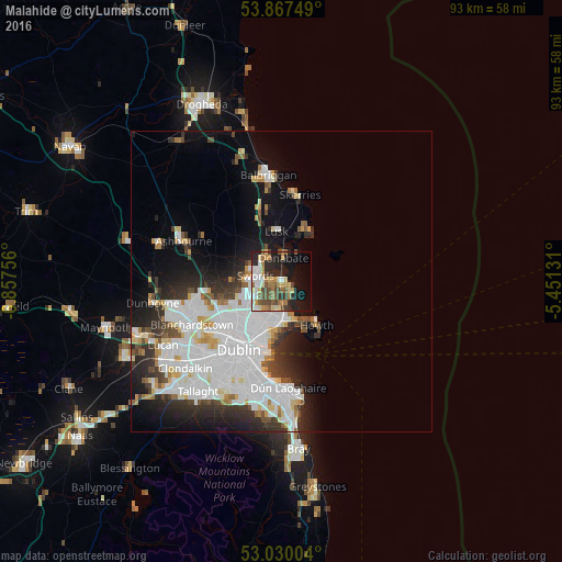
Analysis of Malahide night lights 2016
Square area 10x10 km:
 6.75%
6.75%90-99
5.69%80-89
4.63%70-79
6.48%60-69
7.94%50-59
6.22%40-49
7.28%30-39
3.31%20-29
12.96%10-19
18.92%0-9
19.84%Square area 50x50 km:
7.97%90-99
4.95%80-89
1.6%70-79
1.55%60-69
1.48%50-59
1.3%40-49
1.99%30-39
2.46%20-29
4.6%10-19
7.61%0-9
64.49%Clear (daylight) street map image can be seen on geolist.org.
Map coordinates:
53° 52' 3" North, 6° 51' 27.2" West
53° 27' 3" North, 6° 9' 16" West
53° 1' 48.1" North, 5° 27' 4.7" West
Some cities around Malahide sort by population:
• Swords
4.3 km =2.7 mi,  283°
283°
• Donaghmede
5.8 km =3.6 mi,  184°
184°
• Portmarnock
3.3 km =2.1 mi,  160°
160°
• Baldoyle
6 km =3.7 mi, 161°
• Raheny
7.3 km =4.5 mi,  193°
193°
• Donabate
4 km =2.5 mi,  2°
2°
• Kinsealy-Drinan
3.3 km =2.1 mi,  256°
256°
• Darndale
6.1 km =3.8 mi,  201°
201°
2962725 (p: 15,846)
Sources (retrieved 2019-11-25):
» Earth at Night: Flat Maps 2012, 2016