Kinsealy-Drinan night lights from space
Night Light of Kinsealy-Drinan (Leinster) from space (Ireland) Src. Average luminocity for 10x10km area is 59.5238% and for 50x50km: 22.3851%.
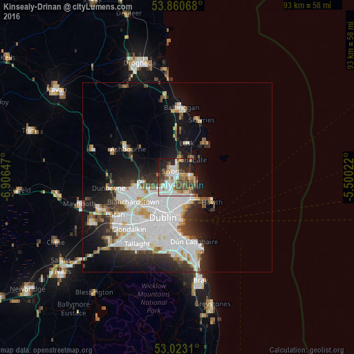
Analysis of Kinsealy-Drinan night lights 2016
Square area 10x10 km:
 15.34%
90-99
13.23%80-89
4.76%70-79
7.67%60-69
9.39%50-59
6.61%40-49
10.45%30-39
5.56%20-29
14.42%10-19
12.17%0-9
0.4%Square area 50x50 km:
8.03%90-99
5.08%80-89
1.66%70-79
1.59%60-69
1.58%50-59
1.44%40-49
2.09%30-39
2.55%20-29
4.78%10-19
8.46%0-9
62.76%Clear (daylight) street map image can be seen on geolist.org.
Map coordinates:
53° 51' 38.4" North, 6° 54' 23.3" West
53° 26' 38.2" North, 6° 12' 12" West
53° 1' 23.2" North, 5° 30' 0.8" West
Some cities around Kinsealy-Drinan sort by population:
• Swords
2 km =1.2 mi,  330°
330°
• Malahide
3.3 km =2.1 mi,  76°
76°
• Donaghmede
5.8 km =3.6 mi,  151°
151°
• Portmarnock
4.9 km =3 mi,  118°
118°
• Raheny
6.5 km =4 mi,  166°
166°
• Donabate
5.9 km =3.7 mi,  35°
35°
• Darndale
5 km =3.1 mi, 169°
• Artane
6.4 km =4 mi,  186°
186°
8658946 (p: 5,814)
Sources (retrieved 2019-11-25):
» Earth at Night: Flat Maps 2012, 2016