Donaghmede night lights from space
Night Light of Donaghmede (Leinster) from space (Ireland) Src. Average luminocity for 10x10km area is 61.5% and for 50x50km: 22.3017%.
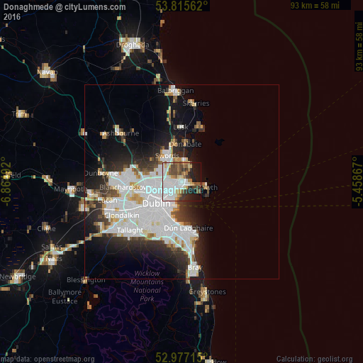
Analysis of Donaghmede night lights 2016
Square area 10x10 km:
 23.81%
90-99
12.3%80-89
3.97%70-79
5.95%60-69
5.82%50-59
8.07%40-49
8.6%30-39
5.16%20-29
8.33%10-19
14.02%0-9
3.97%Square area 50x50 km:
8.14%90-99
5.21%80-89
1.61%70-79
1.59%60-69
1.49%50-59
1.34%40-49
1.95%30-39
2.54%20-29
5.01%10-19
8.38%0-9
62.75%Clear (daylight) street map image can be seen on geolist.org.
Map coordinates:
53° 48' 56.2" North, 6° 51' 53.7" West
53° 23' 54.4" North, 6° 9' 42.4" West
52° 58' 37.7" North, 5° 27' 31.2" West
Some cities around Donaghmede sort by population:
• Portmarnock
3.2 km =2 mi,  30°
30°
• Baldoyle
2.4 km =1.5 mi,  86°
86°
• Donnycarney
4.2 km =2.6 mi,  228°
228°
• Raheny
1.8 km =1.1 mi,  224°
224°
• Darndale
1.8 km =1.1 mi,  273°
273°
• Artane
3.7 km =2.3 mi,  249°
249°
• Killester
4 km =2.5 mi, 225°
• Dollymount
3.9 km =2.4 mi,  198°
198°
6691033 (p: 15,299)
Sources (retrieved 2019-11-25):
» Earth at Night: Flat Maps 2012, 2016