Donabate night lights from space
Night Light of Donabate (Leinster) from space (Ireland) Src. Average luminocity for 10x10km area is 27.6336% and for 50x50km: 20.6295%.
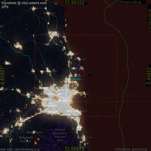
Analysis of Donabate night lights 2016
Square area 10x10 km:
 4.5%
4.5%90-99
3.31%80-89
2.91%70-79
4.5%60-69
3.44%50-59
3.57%40-49
1.85%30-39
1.85%20-29
12.7%10-19
27.91%0-9
33.47%Square area 50x50 km:
7.74%90-99
4.79%80-89
1.53%70-79
1.52%60-69
1.5%50-59
1.29%40-49
1.92%30-39
2.09%20-29
3.56%10-19
6.87%0-9
67.2%Clear (daylight) street map image can be seen on geolist.org.
Map coordinates:
53° 54' 12.7" North, 6° 51' 18.3" West
53° 29' 14" North, 6° 9' 7" West
53° 4' 0.4" North, 5° 26' 55.8" West
Some cities around Donabate sort by population:
• Swords
5.3 km =3.3 mi,  235°
235°
• Malahide
4 km =2.5 mi,  182°
182°
• Donaghmede
9.9 km =6.2 mi, 183°
• Portmarnock
7.2 km =4.5 mi,  172°
172°
• An Ros
5.2 km =3.2 mi,  37°
37°
• Baldoyle
9.9 km =6.2 mi, 169°
• Lusk
4.5 km =2.8 mi,  349°
349°
• Kinsealy-Drinan
5.9 km =3.7 mi,  215°
215°
2964765 (p: 6,778)
Sources (retrieved 2019-11-25):
» Earth at Night: Flat Maps 2012, 2016