Üllő night lights from space
Night Light of Üllő (Pest) from space (Hungary) Src. Average luminocity for 10x10km area is 16.5256% and for 50x50km: 21.3134%.
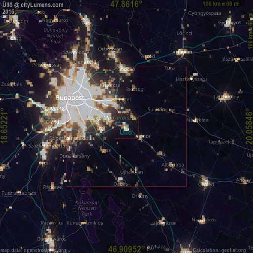
Analysis of Üllő night lights 2016
Square area 10x10 km:
100  0.43%
0.43%
90-99 1.99%
80-89 2.56%
70-79 1.14%
60-69 2.27%
50-59 2.7%
40-49 2.27%
30-39 1.28%
20-29 2.27%
10-19 25.71%
0-9 57.39%
0.43%90-99
1.99%80-89
2.56%70-79
1.14%60-69
2.27%50-59
2.7%40-49
2.27%30-39
1.28%20-29
2.27%10-19
25.71%0-9
57.39%Square area 50x50 km:
100 8.27%
90-99 3.95%
80-89 1.27%
70-79 1.45%
60-69 1.94%
50-59 2.38%
40-49 2.56%
30-39 3.11%
20-29 3.27%
10-19 6.27%
0-9 65.53%
8.27%90-99
3.95%80-89
1.27%70-79
1.45%60-69
1.94%50-59
2.38%40-49
2.56%30-39
3.11%20-29
3.27%10-19
6.27%0-9
65.53%Clear (daylight) street map image can be seen on geolist.org.
Map coordinates:
47° 51' 41.8" North, 18° 39' 8" East
47° 23' 15.8" North, 19° 21' 19.2" East
46° 54' 34.3" North, 20° 3' 30.5" East
Some cities around Üllő sort by population:
• Budapest XVII. kerület
12.8 km =8 mi,  323°
323°
• Gyál
10.1 km =6.3 mi,  267°
267°
• Monor
8 km =5 mi,  120°
120°
• Vecsés
5.6 km =3.5 mi,  292°
292°
• Gyömrő
5.6 km =3.5 mi,  38°
38°
• Pécel
11.4 km =7.1 mi,  354°
354°
• Maglód
6.1 km =3.8 mi,  6°
6°
• Ócsa
13.6 km =8.5 mi,  223°
223°
3043356 (p: 10,232)
Sources (retrieved 2019-11-25):
» Earth at Night: Flat Maps 2012, 2016