Vecsés night lights from space
Night Light of Vecsés (Pest) from space (Hungary) Src. Average luminocity for 10x10km area is 36.4048% and for 50x50km: 26.9469%.
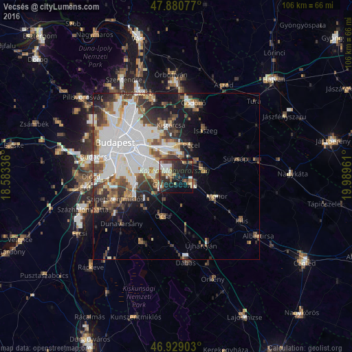
Analysis of Vecsés night lights 2016
Square area 10x10 km:
 5.26%
5.26%90-99
6.25%80-89
4.26%70-79
2.98%60-69
4.55%50-59
4.69%40-49
6.68%30-39
6.11%20-29
14.2%10-19
31.39%0-9
13.64%Square area 50x50 km:
9.76%90-99
5.07%80-89
1.86%70-79
2.01%60-69
2.67%50-59
3.13%40-49
3.45%30-39
4.09%20-29
4.25%10-19
7.92%0-9
55.79%Clear (daylight) street map image can be seen on geolist.org.
Map coordinates:
47° 52' 50.8" North, 18° 35' 0.1" East
47° 24' 25.4" North, 19° 17' 11.3" East
46° 55' 44.5" North, 19° 59' 22.6" East
Some cities around Vecsés sort by population:
• Budapest XVIII. kerület
9.3 km =5.8 mi,  296°
296°
• Budapest XVII. kerület
8.5 km =5.3 mi,  343°
343°
• Budapest XIX. kerület
11.5 km =7.1 mi, 296°
• Gyál
5.5 km =3.4 mi,  242°
242°
• Gyömrő
8.9 km =5.5 mi,  75°
75°
• Pécel
10.1 km =6.3 mi,  24°
24°
• Üllő
5.6 km =3.5 mi,  112°
112°
• Maglód
7.1 km =4.4 mi,  56°
56°
3043019 (p: 19,327)
Sources (retrieved 2019-11-25):
» Earth at Night: Flat Maps 2012, 2016