Pécel night lights from space
Night Light of Pécel (Pest) from space (Hungary) Src. Average luminocity for 10x10km area is 26.2599% and for 50x50km: 25.6983%.
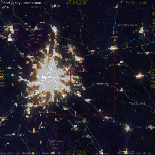
Analysis of Pécel night lights 2016
Square area 10x10 km:
 1.85%
1.85%90-99
3.27%80-89
2.98%70-79
3.84%60-69
4.26%50-59
4.12%40-49
4.26%30-39
5.97%20-29
11.79%10-19
17.76%0-9
39.91%Square area 50x50 km:
9.18%90-99
4.68%80-89
1.64%70-79
1.98%60-69
2.46%50-59
3.05%40-49
3.04%30-39
3.78%20-29
4.42%10-19
9.7%0-9
56.08%Clear (daylight) street map image can be seen on geolist.org.
Map coordinates:
47° 57' 45.3" North, 18° 38' 18.6" East
47° 29' 22.6" North, 19° 20' 29.8" East
47° 0' 44.5" North, 20° 2' 41.1" East
Some cities around Pécel sort by population:
• Budapest XVII. kerület
6.7 km =4.2 mi,  260°
260°
• Vecsés
10.1 km =6.3 mi,  204°
204°
• Gyömrő
8.3 km =5.2 mi,  147°
147°
• Kistarcsa
8.8 km =5.5 mi,  317°
317°
• Isaszeg
6.4 km =4 mi,  45°
45°
• Maglód
5.5 km =3.4 mi,  161°
161°
• Kerepes
9 km =5.6 mi,  330°
330°
• Csömör
10.5 km =6.5 mi,  309°
309°
3046531 (p: 13,193)
Sources (retrieved 2019-11-25):
» Earth at Night: Flat Maps 2012, 2016