Ócsa night lights from space
Night Light of Ócsa (Pest) from space (Hungary) Src. Average luminocity for 10x10km area is 6.067% and for 50x50km: 21.386%.
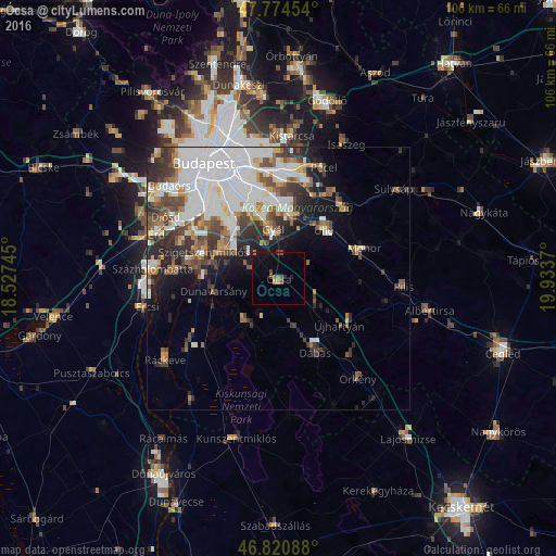
Analysis of Ócsa night lights 2016
Square area 10x10 km:
100  0%
0%
90-99 0%
80-89 0%
70-79 1.19%
60-69 0.89%
50-59 1.49%
40-49 2.08%
30-39 0.3%
20-29 1.34%
10-19 2.98%
0-9 89.73%
0%90-99
0%80-89
0%70-79
1.19%60-69
0.89%50-59
1.49%40-49
2.08%30-39
0.3%20-29
1.34%10-19
2.98%0-9
89.73%Square area 50x50 km:
100 7.46%
90-99 4.04%
80-89 1.31%
70-79 1.79%
60-69 2.04%
50-59 2.6%
40-49 3.13%
30-39 3.15%
20-29 3.95%
10-19 5.28%
0-9 65.25%
7.46%90-99
4.04%80-89
1.31%70-79
1.79%60-69
2.04%50-59
2.6%40-49
3.13%30-39
3.15%20-29
3.95%10-19
5.28%0-9
65.25%Clear (daylight) street map image can be seen on geolist.org.
Map coordinates:
47° 46' 28.3" North, 18° 31' 38.8" East
47° 17' 59.5" North, 19° 13' 50.1" East
46° 49' 15.2" North, 19° 56' 1.3" East
Some cities around Ócsa sort by population:
• Gyál
9.4 km =5.8 mi,  355°
355°
• Vecsés
12.6 km =7.8 mi,  19°
19°
• Dunaharaszti
11.7 km =7.3 mi,  301°
301°
• Dabas
14 km =8.7 mi,  154°
154°
• Üllő
13.6 km =8.5 mi,  43°
43°
• Taksony
12.8 km =8 mi,  285°
285°
• Dunavarsány
12.6 km =7.8 mi,  259°
259°
• Bugyi
10.2 km =6.3 mi,  218°
218°
3047206 (p: 9,097)
Sources (retrieved 2019-11-25):
» Earth at Night: Flat Maps 2012, 2016