Dunavarsány night lights from space
Night Light of Dunavarsány (Pest) from space (Hungary) Src. Average luminocity for 10x10km area is 10.0729% and for 50x50km: 20.753%.
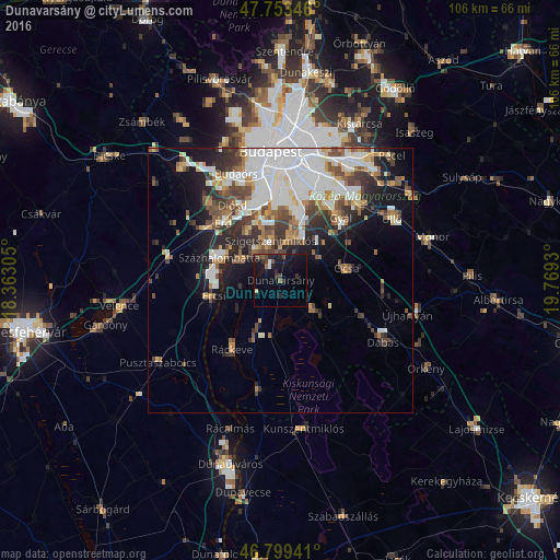
Analysis of Dunavarsány night lights 2016
Square area 10x10 km:
 0.3%
0.3%90-99
0.89%80-89
0.6%70-79
0%60-69
0.15%50-59
2.08%40-49
2.68%30-39
2.23%20-29
3.72%10-19
18.9%0-9
68.45%Square area 50x50 km:
6.22%90-99
4.06%80-89
1.43%70-79
1.89%60-69
2.11%50-59
2.55%40-49
3.18%30-39
2.98%20-29
4.09%10-19
7.45%0-9
64.03%Clear (daylight) street map image can be seen on geolist.org.
Map coordinates:
47° 45' 12.5" North, 18° 21' 47" East
47° 16' 42.9" North, 19° 3' 58.2" East
46° 47' 57.9" North, 19° 46' 9.5" East
Some cities around Dunavarsány sort by population:
• Szigetszentmiklós
7.5 km =4.7 mi,  346°
346°
• Százhalombatta
11.1 km =6.9 mi,  300°
300°
• Dunaharaszti
8.8 km =5.5 mi,  15°
15°
• Szigethalom
6.8 km =4.2 mi,  315°
315°
• Tököl
9.2 km =5.7 mi, 301°
• Kiskunlacháza
10.9 km =6.8 mi,  203°
203°
• Taksony
5.7 km =3.5 mi,  0°
0°
• Bugyi
8.3 km =5.2 mi,  133°
133°
3053434 (p: 6,016)
Sources (retrieved 2019-11-25):
» Earth at Night: Flat Maps 2012, 2016