Dunaharaszti night lights from space
Night Light of Dunaharaszti (Pest) from space (Hungary) Src. Average luminocity for 10x10km area is 44.9554% and for 50x50km: 28.3164%.
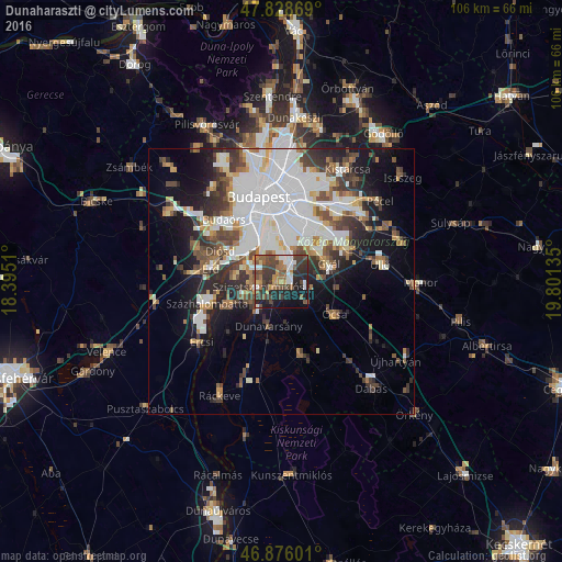
Analysis of Dunaharaszti night lights 2016
Square area 10x10 km:
 6.99%
6.99%90-99
5.8%80-89
0.89%70-79
6.4%60-69
7.59%50-59
8.93%40-49
13.1%30-39
15.18%20-29
13.99%10-19
17.71%0-9
3.42%Square area 50x50 km:
9.66%90-99
5.29%80-89
1.92%70-79
2.35%60-69
2.67%50-59
3.06%40-49
4%30-39
4.16%20-29
5.07%10-19
9.87%0-9
51.97%Clear (daylight) street map image can be seen on geolist.org.
Map coordinates:
47° 49' 43.3" North, 18° 23' 42.4" East
47° 21' 16.2" North, 19° 5' 53.6" East
46° 52' 33.6" North, 19° 48' 4.9" East
Some cities around Dunaharaszti sort by population:
• Budapest XXI. kerület
8.7 km =5.4 mi,  346°
346°
• Budapest XX. kerület
9.1 km =5.7 mi,  1°
1°
• Szigetszentmiklós
4.3 km =2.7 mi,  253°
253°
• Budapest XXIII. kerület
5 km =3.1 mi,  14°
14°
• Szigethalom
8 km =5 mi,  243°
243°
• Halásztelek
8.9 km =5.5 mi,  275°
275°
• Taksony
3.6 km =2.2 mi,  220°
220°
• Dunavarsány
8.8 km =5.5 mi,  195°
195°
3053485 (p: 16,973)
Sources (retrieved 2019-11-25):
» Earth at Night: Flat Maps 2012, 2016