Bugyi night lights from space
Night Light of Bugyi (Pest) from space (Hungary) Src. Average luminocity for 10x10km area is 2.9241% and for 50x50km: 14.4129%.
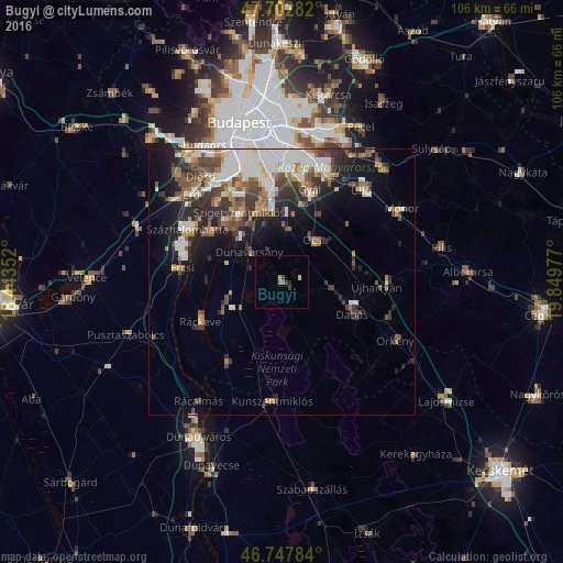
Analysis of Bugyi night lights 2016
Square area 10x10 km:
 0%
0%90-99
0%80-89
0.6%70-79
0.6%60-69
0.6%50-59
0.6%40-49
0.6%30-39
1.19%20-29
0.6%10-19
0%0-9
95.24%Square area 50x50 km:
2.87%90-99
2.79%80-89
1%70-79
1.52%60-69
1.71%50-59
2.02%40-49
2.9%30-39
2.42%20-29
3.59%10-19
6.5%0-9
72.69%Clear (daylight) street map image can be seen on geolist.org.
Map coordinates:
47° 42' 10.2" North, 18° 26' 36.7" East
47° 13' 38.9" North, 19° 8' 47.9" East
46° 44' 52.2" North, 19° 50' 59.2" East
Some cities around Bugyi sort by population:
• Szigetszentmiklós
15.1 km =9.4 mi,  328°
328°
• Dunaharaszti
14.6 km =9.1 mi,  345°
345°
• Dabas
13.2 km =8.2 mi,  110°
110°
• Szigethalom
15.1 km =9.4 mi,  314°
314°
• Ócsa
10.2 km =6.3 mi,  38°
38°
• Kiskunlacháza
11.2 km =7 mi,  247°
247°
• Taksony
12.9 km =8 mi, 332°
• Dunavarsány
8.3 km =5.2 mi, 313°
3054606 (p: 5,412)
Sources (retrieved 2019-11-25):
» Earth at Night: Flat Maps 2012, 2016