Budapest XXIII. kerület night lights from space
Night Light of Budapest XXIII. kerület (Budapest) from space (Hungary) Src. Average luminocity for 10x10km area is 70.8679% and for 50x50km: 31.6285%.
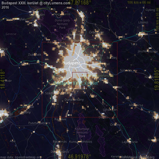
Analysis of Budapest XXIII. kerület night lights 2016
Square area 10x10 km:
 26.56%
90-99
19.6%80-89
2.84%70-79
4.97%60-69
7.24%50-59
6.11%40-49
9.8%30-39
12.22%20-29
9.23%10-19
1.42%0-9
0%Square area 50x50 km:
10.27%90-99
5.89%80-89
2.25%70-79
2.58%60-69
3.24%50-59
3.73%40-49
4.4%30-39
4.77%20-29
5.95%10-19
12.09%0-9
44.84%Clear (daylight) street map image can be seen on geolist.org.
Map coordinates:
47° 52' 18" North, 18° 24' 42.5" East
47° 23' 52.4" North, 19° 6' 53.7" East
46° 55' 11.2" North, 19° 49' 5" East
Some cities around Budapest XXIII. kerület sort by population:
• Kőbánya
9.8 km =6.1 mi,  10°
10°
• Józsefváros
10.7 km =6.6 mi,  342°
342°
• Kispest
6.3 km =3.9 mi,  17°
17°
• Szigetszentmiklós
8.1 km =5 mi,  221°
221°
• Gyál
8.2 km =5.1 mi,  100°
100°
• Dunaharaszti
5 km =3.1 mi,  194°
194°
• Halásztelek
10.8 km =6.7 mi,  248°
248°
• Taksony
8.4 km =5.2 mi,  205°
205°
7284837 (p: 20,387)
Sources (retrieved 2019-11-25):
» Earth at Night: Flat Maps 2012, 2016