Salgótarján night lights from space
Night Light of Salgótarján (Nógrád) from space (Hungary) Src. Average luminocity for 10x10km area is 12.0848% and for 50x50km: 1.2005%.
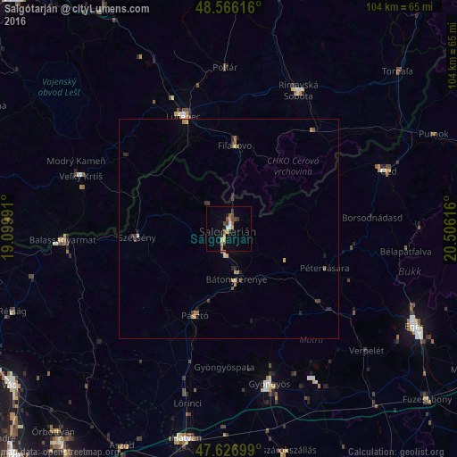
Analysis of Salgótarján night lights 2016
Square area 10x10 km:
 0.89%
0.89%90-99
1.04%80-89
1.04%70-79
2.38%60-69
0.6%50-59
3.57%40-49
1.93%30-39
2.98%20-29
0.74%10-19
2.08%0-9
82.74%Square area 50x50 km:
0.03%90-99
0.07%80-89
0.12%70-79
0.28%60-69
0.16%50-59
0.24%40-49
0.23%30-39
0.26%20-29
0.29%10-19
0.25%0-9
98.06%Clear (daylight) street map image can be seen on geolist.org.
Map coordinates:
48° 33' 58.2" North, 19° 5' 59.7" East
48° 5' 55.4" North, 19° 48' 10.9" East
47° 37' 37.2" North, 20° 30' 22.2" East
Some cities around Salgótarján sort by population:
• Parádsasvár
24.4 km =15.2 mi,  147°
147°
• Lučenec, SK
27.9 km =17.3 mi,  338°
338°
• Rimavská Sobota, SK
35.5 km =22.1 mi,  27°
27°
• Bátonyterenye
14.6 km =9.1 mi,  168°
168°
• Veľký Krtíš, SK
35.8 km =22.2 mi,  290°
290°
• Fiľakovo, SK
18.8 km =11.7 mi,  4°
4°
• Pásztó
21.3 km =13.2 mi,  201°
201°
• Szécsény
21.1 km =13.1 mi,  264°
264°
3045643 (p: 39,640)
Sources (retrieved 2019-11-25):
» Earth at Night: Flat Maps 2012, 2016