Villanueva night lights from space
Night Light of Villanueva (Cortés) from space (Honduras) Src. Average luminocity for 10x10km area is 34.0413% and for 50x50km: 17.481%.
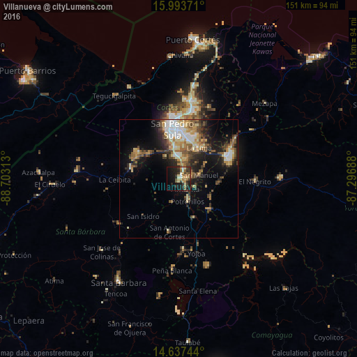
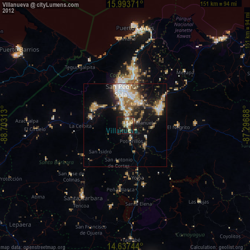
Analysis of Villanueva night lights 2016
Square area 10x10 km:
 1.45%
1.45%90-99
4.55%80-89
5.79%70-79
4.75%60-69
7.23%50-59
4.75%40-49
4.13%30-39
11.36%20-29
9.92%10-19
26.65%0-9
19.42%Square area 50x50 km:
2.03%90-99
2.74%80-89
2.65%70-79
2.45%60-69
2.27%50-59
2.96%40-49
2.84%30-39
3.14%20-29
4.16%10-19
9.68%0-9
65.08%Clear (daylight) street map image can be seen on geolist.org.
Map coordinates:
15° 59' 37.4" North, 88° 42' 11.3" West
15° 19' 0" North, 88° 0' 0" West
14° 38' 14.8" North, 87° 17' 48.8" West
Some cities around Villanueva sort by population:
• San Pedro Sula
21 km =13 mi,  352°
352°
• El Progreso
23.4 km =14.5 mi,  66°
66°
• La Lima
15.8 km =9.8 mi,  34°
34°
• Cofradía
18.6 km =11.6 mi,  299°
299°
• Potrerillos
9.9 km =6.2 mi,  158°
158°
• Pimienta Vieja
9.9 km =6.2 mi, 158°
• Agua Blanca Sur
14.5 km =9 mi,  120°
120°
• San Manuel
9.1 km =5.7 mi,  78°
78°
3600327 (p: 31,571)
Sources (retrieved 2019-11-25):
» Earth at Night: Flat Maps 2012, 2016