Wong Tai Sin night lights from space
Night Light of Wong Tai Sin from space (Hong Kong) Src. Average luminocity for 10x10km area is 88.0436% and for 50x50km: 41.009%.
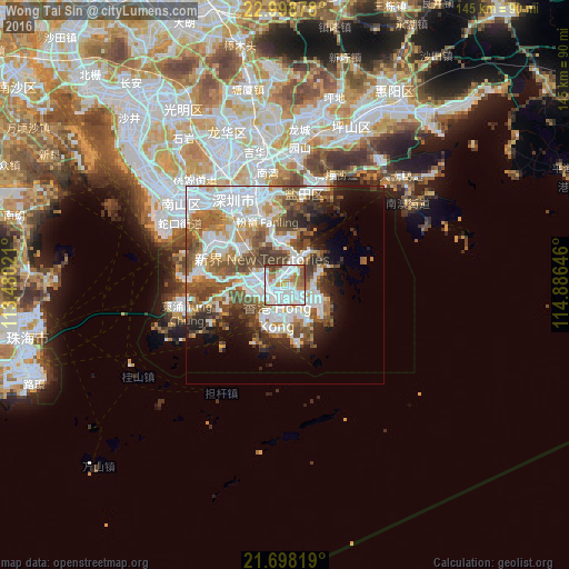
Analysis of Wong Tai Sin night lights 2016
Square area 10x10 km:
 38.26%
90-99
29.55%80-89
1.14%70-79
11.93%60-69
9.09%50-59
4.36%40-49
5.68%30-39
0%20-29
0%10-19
0%0-9
0%Square area 50x50 km:
12.84%90-99
9.12%80-89
2.57%70-79
4.41%60-69
4.82%50-59
6.67%40-49
6.36%30-39
4.33%20-29
4.88%10-19
6.94%0-9
37.08%Clear (daylight) street map image can be seen on geolist.org.
Map coordinates:
22° 59' 55.6" North, 113° 28' 48.8" East
22° 21' 0" North, 114° 10' 60" East
21° 41' 53.5" North, 114° 53' 11.3" East
Some cities around Wong Tai Sin sort by population:
• Hong Kong
8 km =5 mi,  186°
186°
• Kowloon
3.7 km =2.3 mi,  180°
180°
• Tsuen Wan
7.6 km =4.7 mi,  288°
288°
• Sha Tin
3.7 km =2.3 mi,  0°
0°
• Sai Kung
9.3 km =5.8 mi,  66°
66°
• Central
7.9 km =4.9 mi,  198°
198°
• Wan Chai
7.7 km =4.8 mi, 188°
• Sham Shui Po
3.3 km =2.1 mi,  228°
228°
1818304 (p: 0)
Sources (retrieved 2019-11-25):
» Earth at Night: Flat Maps 2012, 2016