Tai Po night lights from space
Night Light of Tai Po from space (Hong Kong) Src. Average luminocity for 10x10km area is 66.0038% and for 50x50km: 58.112%.
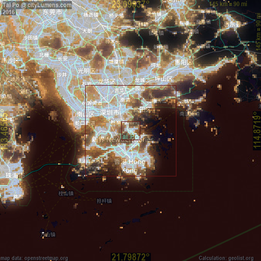
Analysis of Tai Po night lights 2016
Square area 10x10 km:
 17.99%
90-99
14.58%80-89
3.22%70-79
3.41%60-69
8.52%50-59
16.29%40-49
16.48%30-39
16.67%20-29
2.84%10-19
0%0-9
0%Square area 50x50 km:
18.94%90-99
13.48%80-89
4.93%70-79
6.95%60-69
6.41%50-59
8.11%40-49
8.34%30-39
5.84%20-29
4.98%10-19
5.95%0-9
16.05%Clear (daylight) street map image can be seen on geolist.org.
Map coordinates:
23° 5' 54.1" North, 113° 27' 56.3" East
22° 27' 0.3" North, 114° 10' 7.6" East
21° 47' 55.4" North, 114° 52' 18.8" East
Some cities around Tai Po sort by population:
• Shenzhen, CN
14.8 km =9.2 mi,  315°
315°
• Kowloon
14.9 km =9.3 mi,  174°
174°
• Tsuen Wan
10.4 km =6.5 mi,  213°
213°
• Yuen Long Kau Hui
13.9 km =8.6 mi,  269°
269°
• Sha Tin
7.6 km =4.7 mi, 168°
• Sai Kung
12.5 km =7.8 mi,  126°
126°
• Sham Shui Po
13.4 km =8.3 mi,  184°
184°
• Wong Tai Sin
11.2 km =7 mi, 172°
1818673 (p: 16,302)
Sources (retrieved 2019-11-25):
» Earth at Night: Flat Maps 2012, 2016