Vreed-en-Hoop night lights from space
Night Light of Vreed-en-Hoop (Essequibo Islands-West Demerara) from space (Guyana) Src. Average luminocity for 10x10km area is 43.9351% and for 50x50km: 8.2959%.
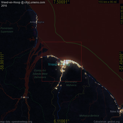
Analysis of Vreed-en-Hoop night lights 2016
Square area 10x10 km:
 7.58%
7.58%90-99
11.69%80-89
3.9%70-79
7.58%60-69
1.52%50-59
2.6%40-49
7.14%30-39
9.09%20-29
12.12%10-19
26.84%0-9
9.96%Square area 50x50 km:
0.8%90-99
1.57%80-89
1.67%70-79
0.86%60-69
0.59%50-59
0.72%40-49
1.21%30-39
1.02%20-29
2.68%10-19
6.72%0-9
82.17%Clear (daylight) street map image can be seen on geolist.org.
Map coordinates:
7° 30' 24.9" North, 58° 54' 4" West
6° 48' 33.4" North, 58° 11' 52.7" West
6° 6' 38.2" North, 57° 29' 41.5" West
Some cities around Vreed-en-Hoop sort by population:
• Georgetown
4.7 km =2.9 mi,  96°
96°
• Linden
89.9 km =55.9 mi,  187°
187°
• New Amsterdam
97.7 km =60.7 mi,  129°
129°
• Anna Regina
61.1 km =38 mi,  325°
325°
• Bartica
64.7 km =40.2 mi,  226°
226°
• Skeldon
156.3 km =97.1 mi, 131°
• Rosignol
94.4 km =58.7 mi, 129°
• Fort Wellington
80.4 km =50 mi, 125°
3375409 (p: 3,073)
Sources (retrieved 2019-11-25):
» Earth at Night: Flat Maps 2012, 2016