Santa Cruz Balanyá night lights from space
Night Light of Santa Cruz Balanyá (Chimaltenango) from space (Guatemala) Src. Average luminocity for 10x10km area is 4.5744% and for 50x50km: 5.5896%.
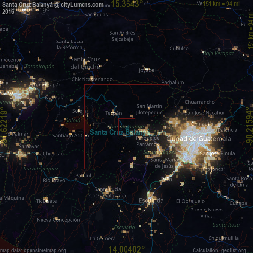
Analysis of Santa Cruz Balanyá night lights 2016
Square area 10x10 km:
 0%
0%90-99
0%80-89
0.83%70-79
0%60-69
0%50-59
0%40-49
3.31%30-39
0.83%20-29
4.13%10-19
0.41%0-9
90.5%Square area 50x50 km:
0.04%90-99
0.25%80-89
0.82%70-79
0.77%60-69
1.18%50-59
0.93%40-49
0.98%30-39
1%20-29
1.52%10-19
6.71%0-9
85.8%Clear (daylight) street map image can be seen on geolist.org.
Map coordinates:
15° 21' 51.5" North, 91° 37' 19.9" West
14° 41' 6.8" North, 90° 55' 8.6" West
14° 0' 14.5" North, 90° 12' 57.4" West
Some cities around Santa Cruz Balanyá sort by population:
• Chimaltenango
11 km =6.8 mi,  104°
104°
• Tecpán Guatemala
11.6 km =7.2 mi,  317°
317°
• Comalapa
7.1 km =4.4 mi,  28°
28°
• Patzún
10.2 km =6.3 mi,  267°
267°
• San Andrés Itzapa
10.8 km =6.7 mi,  130°
130°
• Patzicía
6 km =3.7 mi,  187°
187°
• El Tejar
14.4 km =8.9 mi,  107°
107°
• Zaragoza
5 km =3.1 mi,  141°
141°
3589408 (p: 7,825)
Sources (retrieved 2019-11-25):
» Earth at Night: Flat Maps 2012, 2016