Patzún night lights from space
Night Light of Patzún (Chimaltenango) from space (Guatemala) Src. Average luminocity for 10x10km area is 1.6446% and for 50x50km: 3.2239%.
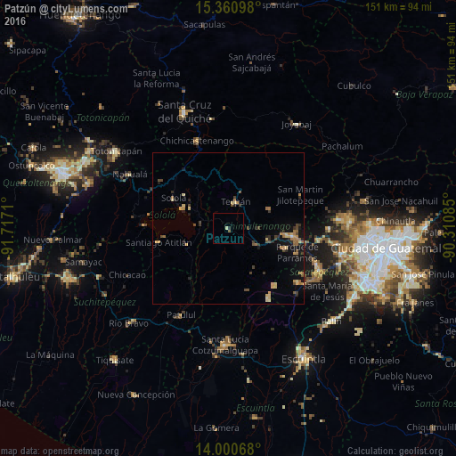
Analysis of Patzún night lights 2016
Square area 10x10 km:
 0%
0%90-99
0.41%80-89
0.41%70-79
0%60-69
0%50-59
0.83%40-49
0%30-39
0%20-29
0.83%10-19
0%0-9
97.52%Square area 50x50 km:
0.02%90-99
0.12%80-89
0.71%70-79
0.5%60-69
0.69%50-59
0.4%40-49
0.72%30-39
0.5%20-29
0.62%10-19
1.98%0-9
93.76%Clear (daylight) street map image can be seen on geolist.org.
Map coordinates:
15° 21' 39.5" North, 91° 43' 1.6" West
14° 40' 54.8" North, 91° 0' 50.3" West
14° 0' 2.4" North, 90° 18' 39.1" West
Some cities around Patzún sort by population:
• Tecpán Guatemala
9.2 km =5.7 mi,  14°
14°
• Comalapa
15.1 km =9.4 mi,  64°
64°
• Patzicía
10.9 km =6.8 mi,  120°
120°
• San Lucas Tolimán
17.2 km =10.7 mi,  235°
235°
• Panajachel
16.7 km =10.4 mi,  293°
293°
• Zaragoza
13.8 km =8.6 mi,  105°
105°
• Santa Cruz Balanyá
10.2 km =6.3 mi,  87°
87°
• Acatenango
16.1 km =10 mi,  151°
151°
3591512 (p: 18,704)
Sources (retrieved 2019-11-25):
» Earth at Night: Flat Maps 2012, 2016