San Andrés Itzapa night lights from space
Night Light of San Andrés Itzapa (Chimaltenango) from space (Guatemala) Src. Average luminocity for 10x10km area is 19.2294% and for 50x50km: 11.8706%.
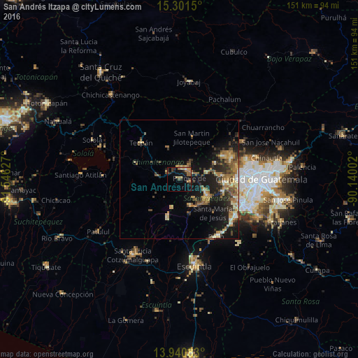
Analysis of San Andrés Itzapa night lights 2016
Square area 10x10 km:
 0.43%
0.43%90-99
0.43%80-89
1.73%70-79
3.9%60-69
6.93%50-59
3.03%40-49
2.6%30-39
1.73%20-29
6.06%10-19
18.4%0-9
54.76%Square area 50x50 km:
0.4%90-99
1.17%80-89
1.92%70-79
1.72%60-69
2.74%50-59
1.97%40-49
2.07%30-39
2.02%20-29
3.24%10-19
9.93%0-9
72.82%Clear (daylight) street map image can be seen on geolist.org.
Map coordinates:
15° 18' 5.4" North, 91° 32' 46.6" West
14° 37' 20" North, 90° 50' 35.3" West
13° 56' 27" North, 90° 8' 24.1" West
Some cities around San Andrés Itzapa sort by population:
• Chimaltenango
5 km =3.1 mi,  30°
30°
• Sumpango
12 km =7.5 mi,  77°
77°
• Patzicía
9 km =5.6 mi,  276°
276°
• El Tejar
6.2 km =3.9 mi,  63°
63°
• Pastores
10 km =6.2 mi,  108°
108°
• Parramos
4.6 km =2.9 mi, 108°
• Zaragoza
5.9 km =3.7 mi,  301°
301°
• Santa Cruz Balanyá
10.8 km =6.7 mi,  310°
310°
3590529 (p: 18,647)
Sources (retrieved 2019-11-25):
» Earth at Night: Flat Maps 2012, 2016