Zaragoza night lights from space
Night Light of Zaragoza (Chimaltenango) from space (Guatemala) Src. Average luminocity for 10x10km area is 10.7857% and for 50x50km: 7.1804%.
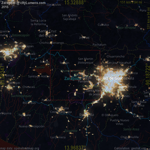
Analysis of Zaragoza night lights 2016
Square area 10x10 km:
 0%
0%90-99
0%80-89
0.87%70-79
1.08%60-69
2.16%50-59
1.08%40-49
3.9%30-39
3.03%20-29
4.76%10-19
6.93%0-9
76.19%Square area 50x50 km:
0.11%90-99
0.43%80-89
0.95%70-79
0.96%60-69
1.61%50-59
1.12%40-49
1.19%30-39
1.36%20-29
2.33%10-19
8.35%0-9
81.58%Clear (daylight) street map image can be seen on geolist.org.
Map coordinates:
15° 19' 44" North, 91° 35' 36.5" West
14° 38' 58.8" North, 90° 53' 25.2" West
13° 58' 6.1" North, 90° 11' 14" West
Some cities around Zaragoza sort by population:
• Chimaltenango
7.7 km =4.8 mi,  80°
80°
• Comalapa
10.1 km =6.3 mi,  1°
1°
• San Andrés Itzapa
5.9 km =3.7 mi,  121°
121°
• Patzicía
4.4 km =2.7 mi,  243°
243°
• El Tejar
10.7 km =6.6 mi,  91°
91°
• Parramos
10.4 km =6.5 mi, 115°
• Santa Cruz Balanyá
5 km =3.1 mi,  321°
321°
• Acatenango
12 km =7.5 mi,  208°
208°
3587543 (p: 9,361)
Sources (retrieved 2019-11-25):
» Earth at Night: Flat Maps 2012, 2016