San Pablo La Laguna night lights from space
Night Light of San Pablo La Laguna (Sololá) from space (Guatemala) Src. Average luminocity for 10x10km area is 2.3285% and for 50x50km: 5.7688%.
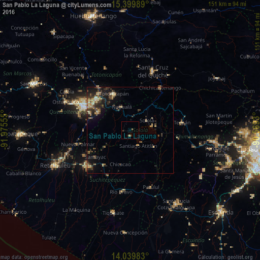
Analysis of San Pablo La Laguna night lights 2016
Square area 10x10 km:
 0%
0%90-99
0%80-89
0%70-79
0.83%60-69
0.83%50-59
0%40-49
1.24%30-39
0.41%20-29
0%10-19
0.83%0-9
95.87%Square area 50x50 km:
0.04%90-99
0.49%80-89
1.14%70-79
0.81%60-69
0.9%50-59
0.64%40-49
1.3%30-39
1.64%20-29
2.08%10-19
4.05%0-9
86.9%Clear (daylight) street map image can be seen on geolist.org.
Map coordinates:
15° 23' 59.6" North, 91° 58' 32" West
14° 43' 15.3" North, 91° 16' 20.7" West
14° 2' 23.4" North, 90° 34' 9.5" West
Some cities around San Pablo La Laguna sort by population:
• Sololá
11.1 km =6.9 mi,  59°
59°
• Santiago Atitlán
10.3 km =6.4 mi,  153°
153°
• Nahualá
14.4 km =8.9 mi,  340°
340°
• Santa Catarina Ixtahuacán
12.6 km =7.8 mi,  312°
312°
• San Lucas Tolimán
19.5 km =12.1 mi,  136°
136°
• Panajachel
12.7 km =7.9 mi,  79°
79°
• Santo Tomás La Unión
17.9 km =11.1 mi,  236°
236°
• Santa Clara La Laguna
3.4 km =2.1 mi,  259°
259°
3589669 (p: 6,186)
Sources (retrieved 2019-11-25):
» Earth at Night: Flat Maps 2012, 2016