Santo Tomás La Unión night lights from space
Night Light of Santo Tomás La Unión (Suchitepeque) from space (Guatemala) Src. Average luminocity for 10x10km area is 1.9048% and for 50x50km: 6.5821%.
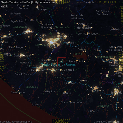
Analysis of Santo Tomás La Unión night lights 2016
Square area 10x10 km:
 0%
0%90-99
0%80-89
0%70-79
0%60-69
0.43%50-59
0.43%40-49
0%30-39
0.87%20-29
1.73%10-19
0.87%0-9
95.67%Square area 50x50 km:
0.28%90-99
0.55%80-89
0.93%70-79
0.82%60-69
1.17%50-59
0.88%40-49
1.27%30-39
1.46%20-29
2.13%10-19
5.17%0-9
85.35%Clear (daylight) street map image can be seen on geolist.org.
Map coordinates:
15° 18' 41.2" North, 92° 6' 50" West
14° 37' 55.9" North, 91° 24' 38.7" West
13° 57' 3" North, 90° 42' 27.5" West
Some cities around Santo Tomás La Unión sort by population:
• Mazatenango
14.8 km =9.2 mi,  222°
222°
• Chicacao
13.5 km =8.4 mi,  137°
137°
• San Pablo Jocopilas
6.5 km =4 mi, 222°
• San Francisco Zapotitlán
12.8 km =8 mi,  248°
248°
• San Antonio Suchitepéquez
10.3 km =6.4 mi,  182°
182°
• Samayac
7.9 km =4.9 mi, 223°
• San Bernardino
11.2 km =7 mi,  207°
207°
• Santa Clara La Laguna
14.8 km =9.2 mi,  51°
51°
3589062 (p: 7,081)
Sources (retrieved 2019-11-25):
» Earth at Night: Flat Maps 2012, 2016