Acatenango night lights from space
Night Light of Acatenango (Chimaltenango) from space (Guatemala) Src. Average luminocity for 10x10km area is 1.5476% and for 50x50km: 5.9292%.
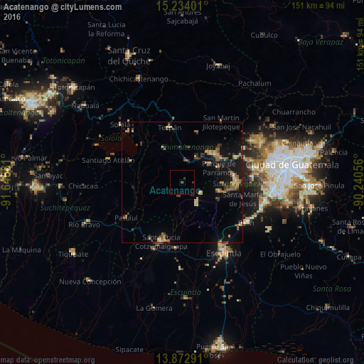
Analysis of Acatenango night lights 2016
Square area 10x10 km:
 0%
0%90-99
0%80-89
0%70-79
0%60-69
0%50-59
0%40-49
1.08%30-39
1.52%20-29
0%10-19
0%0-9
97.4%Square area 50x50 km:
0.04%90-99
0.29%80-89
0.84%70-79
0.96%60-69
1.32%50-59
1.07%40-49
0.94%30-39
0.97%20-29
0.98%10-19
5.92%0-9
86.66%Clear (daylight) street map image can be seen on geolist.org.
Map coordinates:
15° 14' 2.4" North, 91° 38' 48.5" West
14° 33' 16.2" North, 90° 56' 37.2" West
13° 52' 22.5" North, 90° 14' 26" West
Some cities around Acatenango sort by population:
• Patzún
16.1 km =10 mi,  331°
331°
• San Andrés Itzapa
13.2 km =8.2 mi,  55°
55°
• Patzicía
8.8 km =5.5 mi,  12°
12°
• Parramos
16.3 km =10.1 mi,  68°
68°
• Zaragoza
12 km =7.5 mi,  28°
28°
• Yepocapa
5.9 km =3.7 mi,  190°
190°
• San Miguel Dueñas
15.9 km =9.9 mi,  102°
102°
• Santa Cruz Balanyá
14.8 km =9.2 mi, 10°
3600008 (p: 7,050)
Sources (retrieved 2019-11-25):
» Earth at Night: Flat Maps 2012, 2016