Santa Cruz Naranjo night lights from space
Night Light of Santa Cruz Naranjo (Santa Rosa) from space (Guatemala) Src. Average luminocity for 10x10km area is 0.9935% and for 50x50km: 12.5909%.
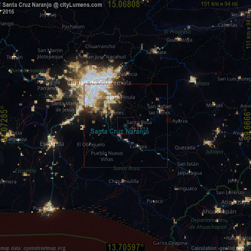
Analysis of Santa Cruz Naranjo night lights 2016
Square area 10x10 km:
 0%
0%90-99
0%80-89
0%70-79
0%60-69
0%50-59
0%40-49
0%30-39
0%20-29
0.43%10-19
1.95%0-9
97.62%Square area 50x50 km:
2.62%90-99
3.01%80-89
1.51%70-79
1.29%60-69
2.04%50-59
1.26%40-49
1.67%30-39
2.05%20-29
1.85%10-19
3.32%0-9
79.38%Clear (daylight) street map image can be seen on geolist.org.
Map coordinates:
15° 4' 5.1" North, 91° 4' 22.3" West
14° 23' 17" North, 90° 22' 11" West
13° 42' 21.5" North, 89° 39' 59.8" West
Some cities around Santa Cruz Naranjo sort by population:
• Petapa
24.3 km =15.1 mi,  301°
301°
• Villa Canales
20.6 km =12.8 mi, 300°
• San José Pinula
18.2 km =11.3 mi,  345°
345°
• Barberena
9 km =5.6 mi,  174°
174°
• Fraijanes
11.5 km =7.1 mi,  318°
318°
• Cuilapa
14.6 km =9.1 mi,  148°
148°
• Nueva Santa Rosa
10.1 km =6.3 mi,  94°
94°
• Casillas
14 km =8.7 mi,  75°
75°
3589398 (p: 6,254)
Sources (retrieved 2019-11-25):
» Earth at Night: Flat Maps 2012, 2016