Casillas night lights from space
Night Light of Casillas (Santa Rosa) from space (Guatemala) Src. Average luminocity for 10x10km area is 2.7121% and for 50x50km: 5.5854%.
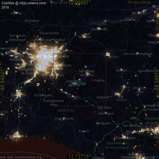
Analysis of Casillas night lights 2016
Square area 10x10 km:
 0%
0%90-99
0%80-89
0.87%70-79
0%60-69
0.87%50-59
0%40-49
0.87%30-39
1.3%20-29
0.43%10-19
0.43%0-9
95.24%Square area 50x50 km:
0.53%90-99
0.91%80-89
0.7%70-79
0.54%60-69
1.41%50-59
0.57%40-49
0.87%30-39
1.52%20-29
1.54%10-19
2.21%0-9
89.2%Clear (daylight) street map image can be seen on geolist.org.
Map coordinates:
15° 5' 56.7" North, 90° 56' 47.1" West
14° 25' 8.9" North, 90° 14' 35.8" West
13° 44' 13.7" North, 89° 32' 24.6" West
Some cities around Casillas sort by population:
• Barberena
17.8 km =11.1 mi,  225°
225°
• Fraijanes
21.9 km =13.6 mi,  283°
283°
• Cuilapa
17 km =10.6 mi,  200°
200°
• Nueva Santa Rosa
5.5 km =3.4 mi,  219°
219°
• Mataquescuintla
13.8 km =8.6 mi,  27°
27°
• San José Acatempa
21.2 km =13.2 mi,  143°
143°
• Santa Cruz Naranjo
14 km =8.7 mi,  255°
255°
• Santa Rosa de Lima
6.6 km =4.1 mi,  238°
238°
3598968 (p: 8,970)
Sources (retrieved 2019-11-25):
» Earth at Night: Flat Maps 2012, 2016