Colomba night lights from space
Night Light of Colomba (Quetzaltenango) from space (Guatemala) Src. Average luminocity for 10x10km area is 3.2727% and for 50x50km: 8.8255%.
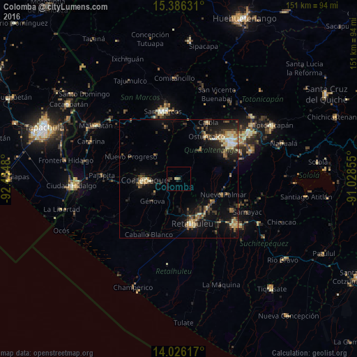
Analysis of Colomba night lights 2016
Square area 10x10 km:
 0%
0%90-99
0.21%80-89
0.62%70-79
0.83%60-69
0%50-59
0.21%40-49
0.83%30-39
1.45%20-29
1.65%10-19
0.83%0-9
93.39%Square area 50x50 km:
0.36%90-99
1.12%80-89
1.27%70-79
1.06%60-69
1.34%50-59
1.03%40-49
1.55%30-39
2%20-29
2.83%10-19
6.92%0-9
80.52%Clear (daylight) street map image can be seen on geolist.org.
Map coordinates:
15° 23' 10.7" North, 92° 26' 5.3" West
14° 42' 26.3" North, 91° 43' 54" West
14° 1' 34.2" North, 91° 1' 42.8" West
Some cities around Colomba sort by population:
• Coatepeque
14.3 km =8.9 mi,  268°
268°
• Nuevo San Carlos
13.3 km =8.3 mi,  162°
162°
• El Palmar
17.7 km =11 mi,  110°
110°
• San Sebastián
18.5 km =11.5 mi,  151°
151°
• El Quetzal
11.5 km =7.1 mi,  306°
306°
• Flores Costa Cuca
16.4 km =10.2 mi,  239°
239°
• San Felipe
17.4 km =10.8 mi,  122°
122°
• El Asintal
12.4 km =7.7 mi,  177°
177°
3598073 (p: 19,115)
Sources (retrieved 2019-11-25):
» Earth at Night: Flat Maps 2012, 2016