Vári night lights from space
Night Light of Vári (Attica) from space (Greece) Src. Average luminocity for 10x10km area is 67.0935% and for 50x50km: 37.5592%.
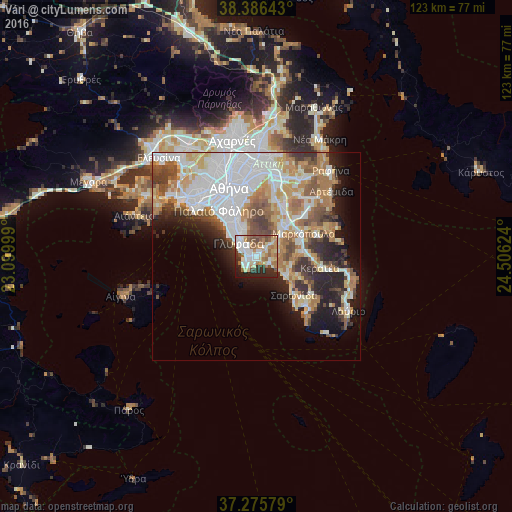
Analysis of Vári night lights 2016
Square area 10x10 km:
 15.14%
90-99
15.82%80-89
11.39%70-79
7.48%60-69
12.76%50-59
9.18%40-49
6.12%30-39
4.42%20-29
13.95%10-19
3.74%0-9
0%Square area 50x50 km:
10.71%90-99
8.2%80-89
3.74%70-79
5.04%60-69
6.06%50-59
3.93%40-49
3.82%30-39
3.62%20-29
6.05%10-19
8.09%0-9
40.74%Clear (daylight) street map image can be seen on geolist.org.
Map coordinates:
38° 23' 11.1" North, 23° 5' 60" East
37° 49' 59.5" North, 23° 48' 11.2" East
37° 16' 32.8" North, 24° 30' 22.5" East
Some cities around Vári sort by population:
• Glyfáda
5.2 km =3.2 mi,  309°
309°
• Ilioúpoli
11.4 km =7.1 mi,  344°
344°
• Álimos
11.1 km =6.9 mi,  320°
320°
• Argyroúpoli
9.3 km =5.8 mi,  330°
330°
• Voúla
2.5 km =1.6 mi,  293°
293°
• Koropí
9.5 km =5.9 mi,  39°
39°
• Ellinikó
8.2 km =5.1 mi, 320°
• Kalývia Thorikoú
10.7 km =6.6 mi,  86°
86°
252270 (p: 15,855)
Sources (retrieved 2019-11-25):
» Earth at Night: Flat Maps 2012, 2016