Ellinikó night lights from space
Night Light of Ellinikó (Attica) from space (Greece) Src. Average luminocity for 10x10km area is 71.0081% and for 50x50km: 46.4337%.
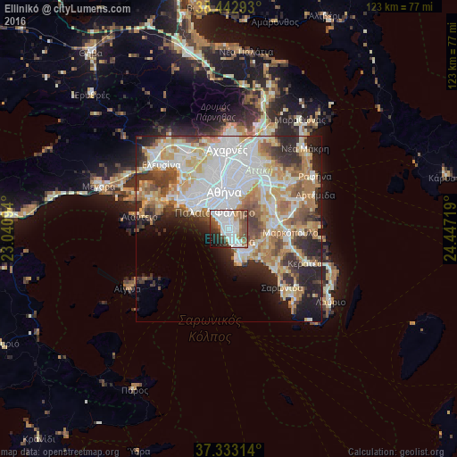
Analysis of Ellinikó night lights 2016
Square area 10x10 km:
 24.35%
90-99
23.21%80-89
2.11%70-79
4.06%60-69
6.17%50-59
12.5%40-49
9.42%30-39
4.55%20-29
8.28%10-19
4.71%0-9
0.65%Square area 50x50 km:
13.46%90-99
10.51%80-89
4.81%70-79
6.58%60-69
7.07%50-59
4.47%40-49
4.66%30-39
4.78%20-29
7.76%10-19
6.91%0-9
29%Clear (daylight) street map image can be seen on geolist.org.
Map coordinates:
38° 26' 34.5" North, 23° 2' 27.4" East
37° 53' 24.5" North, 23° 44' 38.6" East
37° 19' 59.3" North, 24° 26' 49.9" East
Some cities around Ellinikó sort by population:
• Glyfáda
3.3 km =2.1 mi,  157°
157°
• Ilioúpoli
5 km =3.1 mi,  24°
24°
• Néa Smýrni
6.6 km =4.1 mi,  336°
336°
• Agios Dimitrios
4.9 km =3 mi,  348°
348°
• Palaió Fáliro
5.7 km =3.5 mi,  318°
318°
• Álimos
2.9 km =1.8 mi, 321°
• Argyroúpoli
1.8 km =1.1 mi, 17°
• Voúla
6 km =3.7 mi,  151°
151°
262719 (p: 17,259)
Sources (retrieved 2019-11-25):
» Earth at Night: Flat Maps 2012, 2016