Álimos night lights from space
Night Light of Álimos (Attica) from space (Greece) Src. Average luminocity for 10x10km area is 78.1201% and for 50x50km: 47.8845%.
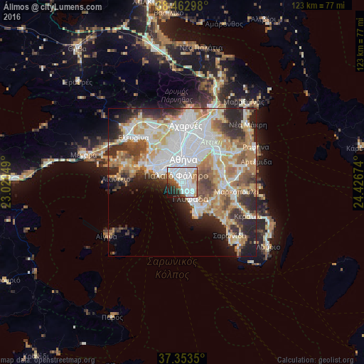

Analysis of Álimos night lights 2016
Square area 10x10 km:
 34.58%
90-99
25.49%80-89
2.6%70-79
5.03%60-69
5.84%50-59
5.36%40-49
5.36%30-39
3.57%20-29
7.31%10-19
4.55%0-9
0.32%Square area 50x50 km:
13.59%90-99
10.85%80-89
5.11%70-79
6.79%60-69
7.2%50-59
4.68%40-49
4.93%30-39
5.08%20-29
8.56%10-19
6.44%0-9
26.77%Clear (daylight) street map image can be seen on geolist.org.
Map coordinates:
38° 27' 46.7" North, 23° 1' 13.8" East
37° 54' 37.2" North, 23° 43' 25" East
37° 21' 12.6" North, 24° 25' 36.3" East
Some cities around Álimos sort by population:
• Kallithéa
4.9 km =3 mi,  334°
334°
• Ilioúpoli
4.5 km =2.8 mi,  58°
58°
• Néa Smýrni
3.9 km =2.4 mi,  347°
347°
• Agios Dimitrios
2.7 km =1.7 mi,  18°
18°
• Palaió Fáliro
2.8 km =1.7 mi,  314°
314°
• Argyroúpoli
2.4 km =1.5 mi,  101°
101°
• Dhafní
4.5 km =2.8 mi,  12°
12°
• Ellinikó
2.9 km =1.8 mi,  141°
141°
261614 (p: 41,720)
Sources (retrieved 2019-11-25):
» Earth at Night: Flat Maps 2012, 2016