Rafína night lights from space
Night Light of Rafína (Attica) from space (Greece) Src. Average luminocity for 10x10km area is 41.5666% and for 50x50km: 33.4603%.
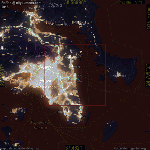
Analysis of Rafína night lights 2016
Square area 10x10 km:
 1.46%
1.46%90-99
5.03%80-89
2.76%70-79
8.93%60-69
22.08%50-59
6.49%40-49
4.22%30-39
5.68%20-29
7.79%10-19
17.21%0-9
18.34%Square area 50x50 km:
8.35%90-99
7.43%80-89
3.57%70-79
4.72%60-69
5.84%50-59
3.73%40-49
3.19%30-39
3.97%20-29
6.52%10-19
6.32%0-9
46.35%Clear (daylight) street map image can be seen on geolist.org.
Map coordinates:
38° 34' 11.9" North, 23° 18' 10.3" East
38° 1' 5.2" North, 24° 0' 21.6" East
37° 27' 43.6" North, 24° 42' 32.8" East
Some cities around Rafína sort by population:
• Gérakas
13 km =8.1 mi,  272°
272°
• Artémida
5.7 km =3.5 mi,  188°
188°
• Néa Mákri
8.1 km =5 mi,  341°
341°
• Pallíni
10.9 km =6.8 mi,  262°
262°
• Limín Mesoyaías
14.1 km =8.8 mi,  181°
181°
• Spáta
10.1 km =6.3 mi,  231°
231°
• Néa Pentéli
13.7 km =8.5 mi,  290°
290°
• Leondárion
13.7 km =8.5 mi, 255°
254425 (p: 12,168)
Sources (retrieved 2019-11-25):
» Earth at Night: Flat Maps 2012, 2016