Psachná night lights from space
Night Light of Psachná (Central Greece) from space (Greece) Src. Average luminocity for 10x10km area is 10.8718% and for 50x50km: 6.7626%.
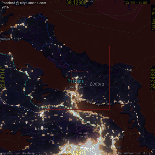
Analysis of Psachná night lights 2016
Square area 10x10 km:
 0.16%
0.16%90-99
0.49%80-89
0%70-79
1.14%60-69
4.06%50-59
0.65%40-49
0.97%30-39
5.36%20-29
2.76%10-19
7.79%0-9
76.62%Square area 50x50 km:
0.2%90-99
0.75%80-89
0.69%70-79
0.75%60-69
1.93%50-59
0.7%40-49
1%30-39
1.69%20-29
2.94%10-19
5.36%0-9
83.98%Clear (daylight) street map image can be seen on geolist.org.
Map coordinates:
39° 7' 33.9" North, 22° 56' 24.5" East
38° 34' 42.7" North, 23° 38' 35.7" East
38° 1' 36.3" North, 24° 20' 47" East
Some cities around Psachná sort by population:
• Chalkída
13.3 km =8.3 mi,  195°
195°
• Thívai
39.9 km =24.8 mi,  225°
225°
• Néa Artáki
6.5 km =4 mi,  187°
187°
• Vasilikón
17.2 km =10.7 mi,  171°
171°
• Thrakomakedónes
50.9 km =31.6 mi, 168°
• Avlónas
36.6 km =22.7 mi, 172°
• Alivéri
38.4 km =23.9 mi,  117°
117°
• Dhrosiá
13.4 km =8.3 mi,  218°
218°
254546 (p: 5,828)
Sources (retrieved 2019-11-25):
» Earth at Night: Flat Maps 2012, 2016