Dhrosiá night lights from space
Night Light of Dhrosiá (Central Greece) from space (Greece) Src. Average luminocity for 10x10km area is 24.0601% and for 50x50km: 12.2452%.
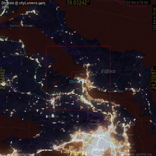
Analysis of Dhrosiá night lights 2016
Square area 10x10 km:
 1.95%
1.95%90-99
5.36%80-89
2.6%70-79
3.41%60-69
2.27%50-59
3.25%40-49
1.3%30-39
4.71%20-29
10.55%10-19
20.78%0-9
43.83%Square area 50x50 km:
0.54%90-99
1.43%80-89
1.41%70-79
1.18%60-69
3.27%50-59
1.36%40-49
1.91%30-39
2.9%20-29
4.25%10-19
11.71%0-9
70.04%Clear (daylight) street map image can be seen on geolist.org.
Map coordinates:
39° 1' 56.7" North, 22° 50' 40.6" East
38° 29' 2.9" North, 23° 32' 51.9" East
37° 55' 53.9" North, 24° 15' 3.1" East
Some cities around Dhrosiá sort by population:
• Chalkída
5.3 km =3.3 mi,  115°
115°
• Thívai
26.7 km =16.6 mi,  228°
228°
• Néa Artáki
8.4 km =5.2 mi,  61°
61°
• Vasilikón
12.6 km =7.8 mi, 120°
• Thrakomakedónes
43.5 km =27 mi,  155°
155°
• Psachná
13.4 km =8.3 mi,  38°
38°
• Avlónas
28.9 km =18 mi,  153°
153°
• Alivéri
42.9 km =26.7 mi,  100°
100°
262869 (p: 5,020)
Sources (retrieved 2019-11-25):
» Earth at Night: Flat Maps 2012, 2016