Alivéri night lights from space
Night Light of Alivéri (Central Greece) from space (Greece) Src. Average luminocity for 10x10km area is 10.0633% and for 50x50km: 4.6853%.
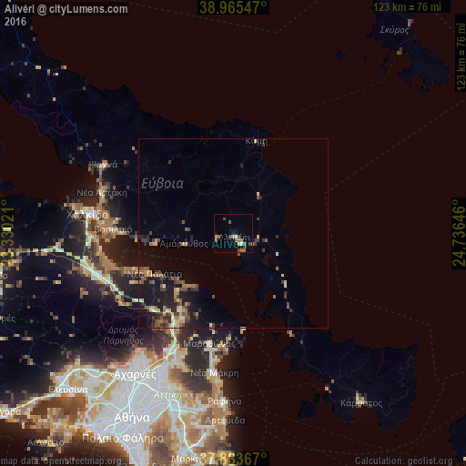
Analysis of Alivéri night lights 2016
Square area 10x10 km:
 0.49%
0.49%90-99
1.46%80-89
0.32%70-79
0.32%60-69
4.71%50-59
0.81%40-49
2.92%30-39
2.27%20-29
0%10-19
0.65%0-9
86.04%Square area 50x50 km:
0.07%90-99
0.5%80-89
0.56%70-79
0.44%60-69
1.06%50-59
0.72%40-49
0.97%30-39
1.32%20-29
1.11%10-19
4.32%0-9
88.94%Clear (daylight) street map image can be seen on geolist.org.
Map coordinates:
38° 57' 55.7" North, 23° 19' 48.8" East
38° 25' 0" North, 24° 1' 60" East
37° 51' 49.2" North, 24° 44' 11.3" East
Some cities around Alivéri sort by population:
• Ágios Stéfanos
33.8 km =21 mi,  207°
207°
• Néa Artáki
36.7 km =22.8 mi,  288°
288°
• Drosiá
36.2 km =22.5 mi,  204°
204°
• Marathónas
29.9 km =18.6 mi,  191°
191°
• Vasilikón
31.5 km =19.6 mi,  271°
271°
• Anoixi
35.1 km =21.8 mi, 205°
• Avlónas
34.7 km =21.6 mi,  238°
238°
• Kryonéri
35.8 km =22.2 mi, 209°
265309 (p: 5,184)
Sources (retrieved 2019-11-25):
» Earth at Night: Flat Maps 2012, 2016