Avlónas night lights from space
Night Light of Avlónas (Attica) from space (Greece) Src. Average luminocity for 10x10km area is 18.9762% and for 50x50km: 30.0586%.
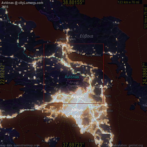
Analysis of Avlónas night lights 2016
Square area 10x10 km:
 0.34%
0.34%90-99
2.72%80-89
4.08%70-79
1.02%60-69
2.72%50-59
1.19%40-49
1.87%30-39
4.42%20-29
5.44%10-19
27.72%0-9
48.47%Square area 50x50 km:
5.87%90-99
5.95%80-89
3.56%70-79
3.61%60-69
4.73%50-59
2.44%40-49
3.48%30-39
4.86%20-29
8.92%10-19
14.45%0-9
42.12%Clear (daylight) street map image can be seen on geolist.org.
Map coordinates:
38° 48' 5.6" North, 22° 59' 32.7" East
38° 15' 5.4" North, 23° 41' 43.9" East
37° 41' 50" North, 24° 23' 55.2" East
Some cities around Avlónas sort by population:
• Acharnés
19 km =11.8 mi,  169°
169°
• Áno Liósia
18.7 km =11.6 mi,  178°
178°
• Ágios Stéfanos
18.2 km =11.3 mi,  129°
129°
• Vasilikón
19.5 km =12.1 mi,  353°
353°
• Anoixi
19.4 km =12.1 mi, 132°
• Thrakomakedónes
14.6 km =9.1 mi,  158°
158°
• Ekáli
19.9 km =12.4 mi,  142°
142°
• Kryonéri
17.3 km =10.7 mi, 137°
264310 (p: 5,744)
Sources (retrieved 2019-11-25):
» Earth at Night: Flat Maps 2012, 2016