Thrakomakedónes night lights from space
Night Light of Thrakomakedónes (Attica) from space (Greece) Src. Average luminocity for 10x10km area is 61.0034% and for 50x50km: 45.7379%.
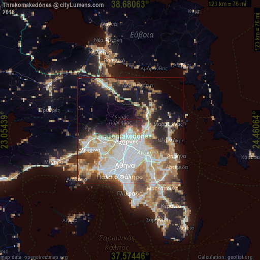
Analysis of Thrakomakedónes night lights 2016
Square area 10x10 km:
 16.5%
16.5%90-99
16.84%80-89
4.25%70-79
7.48%60-69
9.52%50-59
4.08%40-49
6.63%30-39
4.59%20-29
18.2%10-19
10.71%0-9
1.19%Square area 50x50 km:
12.45%90-99
9.85%80-89
4.86%70-79
6.14%60-69
6.77%50-59
4.46%40-49
4.76%30-39
5.15%20-29
8.3%10-19
12.73%0-9
24.54%Clear (daylight) street map image can be seen on geolist.org.
Map coordinates:
38° 40' 50.3" North, 23° 3' 15.8" East
38° 7' 46.7" North, 23° 45' 27" East
37° 34' 28.1" North, 24° 27' 38.3" East
Some cities around Thrakomakedónes sort by population:
• Acharnés
5.6 km =3.5 mi,  202°
202°
• Kifisiá
7.7 km =4.8 mi,  142°
142°
• Áno Liósia
7.2 km =4.5 mi,  224°
224°
• Metamórfosi
7.1 km =4.4 mi,  175°
175°
• Néa Erythraía
7 km =4.3 mi,  125°
125°
• Lykóvrysi
7 km =4.3 mi,  162°
162°
• Ekáli
7.1 km =4.4 mi,  107°
107°
• Kryonéri
6.4 km =4 mi,  82°
82°
9035859 (p: 6,200)
Sources (retrieved 2019-11-25):
» Earth at Night: Flat Maps 2012, 2016