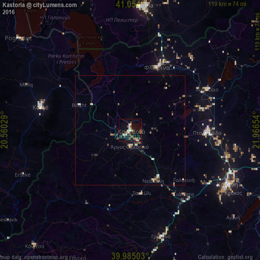
Kastoria night lights from space
Night Light of Kastoria (West Macedonia) from space (Greece) Src. Average luminocity for 10x10km area is 22.6548% and for 50x50km: 2.5286%.
Analysis of Kastoria night lights 2016
Square area 10x10 km:
 2.72%
2.72%90-99
3.91%80-89
2.38%70-79
2.38%60-69
1.36%50-59
2.55%40-49
3.4%30-39
4.76%20-29
4.25%10-19
28.06%0-9
44.22%Square area 50x50 km:
0.13%90-99
0.47%80-89
0.25%70-79
0.3%60-69
0.3%50-59
0.25%40-49
0.47%30-39
0.56%20-29
0.58%10-19
1.54%0-9
95.15%Clear (daylight) street map image can be seen on geolist.org.
Map coordinates:
41° 3' 14.4" North, 20° 33' 37" East
40° 31' 17.9" North, 21° 15' 48.3" East
39° 59' 6.1" North, 21° 57' 59.5" East
Some cities around Kastoria sort by population:
• Korçë, AL
42.2 km =26.2 mi,  284°
284°
• Kozáni
50.8 km =31.6 mi,  118°
118°
• Ptolemaḯda
35.1 km =21.8 mi,  91°
91°
• Flórina
31.5 km =19.6 mi,  23°
23°
• Grevená
50.6 km =31.4 mi,  164°
164°
• Argos Orestiko
7.6 km =4.7 mi,  182°
182°
• Bilisht, AL
25.9 km =16.1 mi,  297°
297°
• Siátista
37.4 km =23.2 mi,  140°
140°
735927 (p: 13,387)
Sources (retrieved 2019-11-25):
» Earth at Night: Flat Maps 2012, 2016