Grevená night lights from space
Night Light of Grevená (West Macedonia) from space (Greece) Src. Average luminocity for 10x10km area is 13.1136% and for 50x50km: 2.1502%.
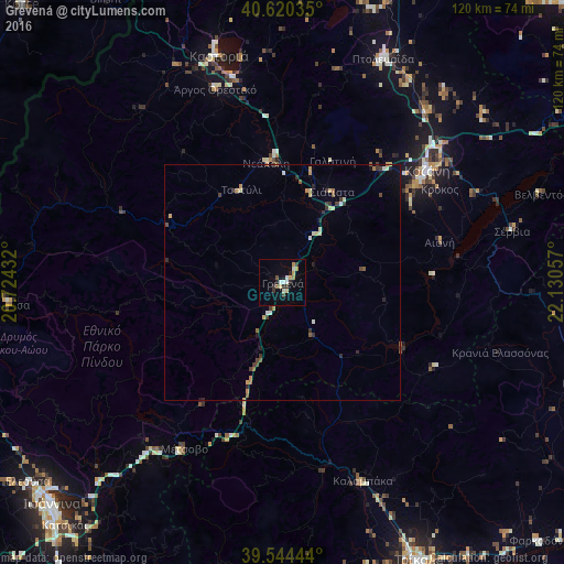
Analysis of Grevená night lights 2016
Square area 10x10 km:
 0.97%
0.97%90-99
3.08%80-89
1.95%70-79
1.46%60-69
1.14%50-59
0.81%40-49
0.97%30-39
2.6%20-29
1.79%10-19
2.27%0-9
82.95%Square area 50x50 km:
0.04%90-99
0.38%80-89
0.4%70-79
0.23%60-69
0.22%50-59
0.27%40-49
0.23%30-39
0.58%20-29
0.35%10-19
0.26%0-9
97.03%Clear (daylight) street map image can be seen on geolist.org.
Map coordinates:
40° 37' 13.3" North, 20° 43' 27.6" East
40° 5' 4.3" North, 21° 25' 38.8" East
39° 32' 40" North, 22° 7' 50.1" East
Some cities around Grevená sort by population:
• Ioánnina
67.7 km =42.1 mi,  226°
226°
• Tríkala
65.7 km =40.8 mi,  153°
153°
• Kozáni
39 km =24.2 mi,  51°
51°
• Ptolemaḯda
52.4 km =32.6 mi,  24°
24°
• Kastoria
50.6 km =31.4 mi,  344°
344°
• Kalampáka
45.6 km =28.3 mi,  158°
158°
• Argos Orestiko
43.5 km =27 mi, 340°
• Siátista
22.1 km =13.7 mi,  26°
26°
736151 (p: 10,563)
Sources (retrieved 2019-11-25):
» Earth at Night: Flat Maps 2012, 2016