Mikomeseng night lights from space
Night Light of Mikomeseng (Kié-Ntem) from space (Equatorial Guinea) Src. Average luminocity for 10x10km area is 2.0974% and for 50x50km: 5.5697%.
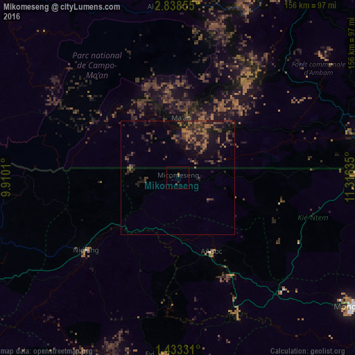
Analysis of Mikomeseng night lights 2016
Square area 10x10 km:
 0%
0%90-99
0%80-89
0%70-79
0%60-69
0.87%50-59
0.87%40-49
0.43%30-39
0.65%20-29
0.65%10-19
1.52%0-9
95.02%Square area 50x50 km:
0%90-99
0%80-89
0%70-79
0.39%60-69
1.62%50-59
1.32%40-49
1.96%30-39
1.9%20-29
2.81%10-19
5.2%0-9
84.8%Clear (daylight) street map image can be seen on geolist.org.
Map coordinates:
2° 50' 18.8" North, 9° 54' 36.4" East
2° 8' 9.9" North, 10° 36' 47.6" East
1° 25' 59.9" North, 11° 18' 58.9" East
Some cities around Mikomeseng sort by population:
• Bata
98.9 km =61.5 mi,  252°
252°
• Ebebiyin
80.2 km =49.8 mi,  88°
88°
• Bitam, GA
98.8 km =61.4 mi, 93°
• Añisoc
34.7 km =21.6 mi,  150°
150°
• Akom II, CM
72.2 km =44.9 mi,  355°
355°
• Ambam, CM
79.4 km =49.3 mi,  69°
69°
• Evinayong
78.1 km =48.5 mi,  185°
185°
• Mongomo
96.2 km =59.8 mi,  126°
126°
2307970 (p: 5,813)
Sources (retrieved 2019-11-25):
» Earth at Night: Flat Maps 2012, 2016