Ambam night lights from space
Night Light of Ambam (South) from space (Cameroon) Src. Average luminocity for 10x10km area is 1.3983% and for 50x50km: 2.5693%.
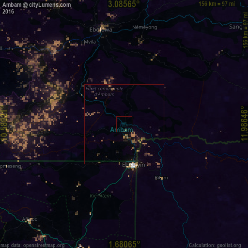
Analysis of Ambam night lights 2016
Square area 10x10 km:
 0%
0%90-99
0%80-89
0%70-79
0%60-69
0.43%50-59
0.43%40-49
0%30-39
0%20-29
0.43%10-19
0%0-9
98.7%Square area 50x50 km:
0%90-99
0%80-89
0%70-79
0.44%60-69
0.73%50-59
0.5%40-49
0.74%30-39
0.44%20-29
0.97%10-19
1.24%0-9
94.94%Clear (daylight) street map image can be seen on geolist.org.
Map coordinates:
3° 5' 8.3" North, 10° 34' 48.8" East
2° 22' 60" North, 11° 16' 60" East
1° 40' 50.3" North, 11° 59' 11.3" East
Some cities around Ambam sort by population:
• Ébolowa
59.3 km =36.8 mi,  345°
345°
• Oyem, GA
93.2 km =57.9 mi,  159°
159°
• Ebebiyin, GQ
26.5 km =16.5 mi,  167°
167°
• Bitam, GA
41.8 km =26 mi,  144°
144°
• Añisoc, GQ
81.1 km =50.4 mi,  224°
224°
• Akom II
91.2 km =56.7 mi,  299°
299°
• Mongomo, GQ
84.1 km =52.3 mi,  177°
177°
• Mikomeseng, GQ
79.4 km =49.3 mi,  249°
249°
2235660 (p: 8,476)
Sources (retrieved 2019-11-25):
» Earth at Night: Flat Maps 2012, 2016