Wenchi night lights from space
Night Light of Wenchi (Brong-Ahafo) from space (Ghana) Src. Average luminocity for 10x10km area is 10.5021% and for 50x50km: 2.4575%.

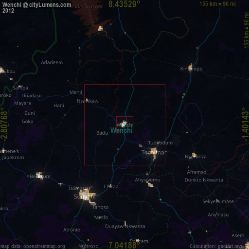
Analysis of Wenchi night lights 2016
Square area 10x10 km:
 0%
0%90-99
0.83%80-89
4.13%70-79
2.07%60-69
0.41%50-59
1.65%40-49
0.83%30-39
1.65%20-29
1.65%10-19
1.24%0-9
85.54%Square area 50x50 km:
0.04%90-99
0.13%80-89
0.41%70-79
0.68%60-69
0.48%50-59
0.29%40-49
0.3%30-39
0.35%20-29
0.39%10-19
1.92%0-9
95.01%Clear (daylight) street map image can be seen on geolist.org.
Map coordinates:
8° 26' 7" North, 2° 48' 27.6" West
7° 44' 21" North, 2° 6' 16.4" West
7° 2' 30.8" North, 1° 24' 5.1" West
Some cities around Wenchi sort by population:
• Japekrom
77.2 km =48 mi,  256°
256°
• Sunyani
50.7 km =31.5 mi,  208°
208°
• Techiman
25.2 km =15.7 mi,  133°
133°
• Berekum
61.7 km =38.3 mi,  238°
238°
• Bondoukou, CI
83.6 km =51.9 mi,  293°
293°
• Kintampo
54.2 km =33.7 mi,  49°
49°
• Bechem
72.7 km =45.2 mi,  173°
173°
• Duayaw-Nkwanta
62.7 km =39 mi,  179°
179°
2294086 (p: 31,411)
Sources (retrieved 2019-11-25):
» Earth at Night: Flat Maps 2012, 2016