Keta night lights from space
Night Light of Keta (Volta) from space (Ghana) Src. Average luminocity for 10x10km area is 10.6653% and for 50x50km: 4.19%.
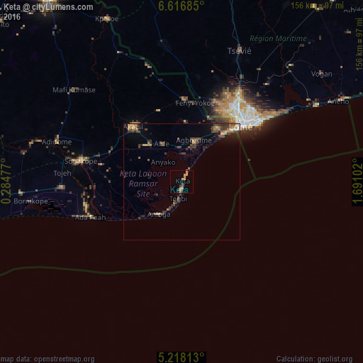
Analysis of Keta night lights 2016
Square area 10x10 km:
100  0%
0%
90-99 0%
80-89 3.1%
70-79 4.96%
60-69 0.83%
50-59 0.83%
40-49 2.27%
30-39 1.24%
20-29 0%
10-19 0.21%
0-9 86.57%
0%90-99
0%80-89
3.1%70-79
4.96%60-69
0.83%50-59
0.83%40-49
2.27%30-39
1.24%20-29
0%10-19
0.21%0-9
86.57%Square area 50x50 km:
100 0.09%
90-99 0.12%
80-89 0.69%
70-79 0.58%
60-69 0.81%
50-59 0.43%
40-49 1.3%
30-39 1.47%
20-29 0.95%
10-19 1.57%
0-9 91.98%
0.09%90-99
0.12%80-89
0.69%70-79
0.58%60-69
0.81%50-59
0.43%40-49
1.3%30-39
1.47%20-29
0.95%10-19
1.57%0-9
91.98%Clear (daylight) street map image can be seen on geolist.org.
Map coordinates:
6° 37' 0.7" North, 0° 17' 5.2" East
5° 55' 4.5" North, 0° 59' 16.4" East
5° 13' 5.3" North, 1° 41' 27.7" East
Some cities around Keta sort by population:
• Lomé, TG
34.9 km =21.7 mi,  47°
47°
• Ho
95 km =59 mi,  323°
323°
• Aflao
31.7 km =19.7 mi,  44°
44°
• Tsévié, TG
61.8 km =38.4 mi,  23°
23°
• Aného, TG
75.2 km =46.7 mi,  62°
62°
• Anloga
17 km =10.6 mi,  216°
216°
• Vogan, TG
76 km =47.2 mi, 52°
• Tabligbo, TG
93.2 km =57.9 mi, 37°
2299645 (p: 18,077)
Sources (retrieved 2019-11-25):
» Earth at Night: Flat Maps 2012, 2016