Akropong night lights from space
Night Light of Akropong (Eastern) from space (Ghana) Src. Average luminocity for 10x10km area is 12.0083% and for 50x50km: 17.5436%.
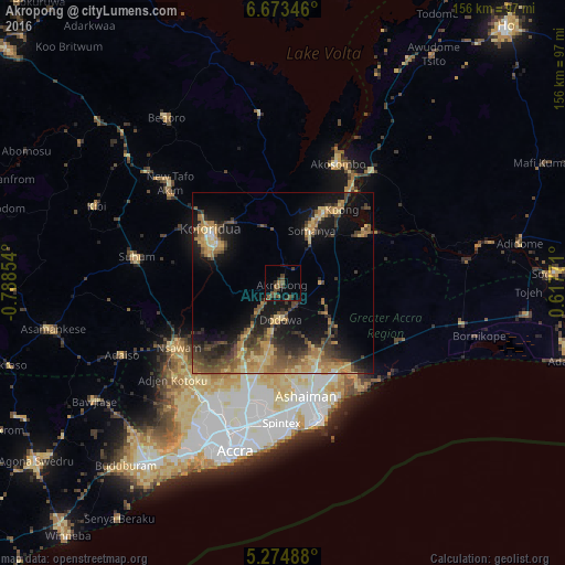
Analysis of Akropong night lights 2016
Square area 10x10 km:
 0%
0%90-99
0%80-89
0%70-79
0%60-69
1.86%50-59
6.2%40-49
5.58%30-39
3.72%20-29
3.31%10-19
6.61%0-9
72.73%Square area 50x50 km:
0.21%90-99
0.7%80-89
3.35%70-79
3.45%60-69
4.07%50-59
3.1%40-49
4.06%30-39
4.18%20-29
4.31%10-19
11.25%0-9
61.32%Clear (daylight) street map image can be seen on geolist.org.
Map coordinates:
6° 40' 24.5" North, 0° 47' 18.7" West
5° 58' 28.6" North, 0° 5' 7.5" West
5° 16' 29.6" North, 0° 37' 3.8" East
Some cities around Akropong sort by population:
• Atsiaman
40.9 km =25.4 mi,  221°
221°
• Tema
34.7 km =21.6 mi,  167°
167°
• Medina Estates
35.4 km =22 mi,  194°
194°
• Koforidua
23.4 km =14.5 mi,  304°
304°
• Suhum
41 km =25.5 mi,  280°
280°
• Dome
39.8 km =24.7 mi,  204°
204°
• Nsawam
34.6 km =21.5 mi,  237°
237°
• Aburi
17.2 km =10.7 mi,  214°
214°
2305027 (p: 11,096)
Sources (retrieved 2019-11-25):
» Earth at Night: Flat Maps 2012, 2016